
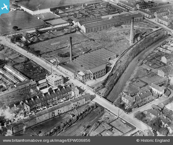
EPW036856 ENGLAND (1931). The Kingston Confectionery Works on Hopwood Lane, Halifax, 1931
© Copyright OpenStreetMap contributors and licensed by the OpenStreetMap Foundation. 2024. Cartography is licensed as CC BY-SA.
Nearby Images (23)
EPW036856

EPW036851

EPW036850

EPW036854

EPW036855

EPW036852

EPW036853

EAW004555

EAW028038

EAW028035

EAW004551

EAW028041

EAW028030

EAW028031

EAW028039

EAW004552

EAW028034

EAW028040

EAW004557

EAW004554

EAW004553

EAW004556

EAW004558

Details
| Title | [EPW036856] The Kingston Confectionery Works on Hopwood Lane, Halifax, 1931 |
| Reference | EPW036856 |
| Date | September-1931 |
| Link | |
| Place name | HALIFAX |
| Parish | |
| District | |
| Country | ENGLAND |
| Easting / Northing | 407758, 424919 |
| Longitude / Latitude | -1.8824218169481, 53.720398612773 |
| National Grid Reference | SE078249 |
Pins
 RT |
Monday 12th of March 2018 02:45:12 PM | |
David |
Monday 21st of January 2013 01:41:14 PM | |
What are the strange uprights, looking over the backs of houses on Vickerman Street? They appear to be in line with the windows of the houses. What are they for? Who would have installed them? I'm intrigued... |
Scouseinmanc |
Tuesday 23rd of January 2018 04:28:01 PM |


