
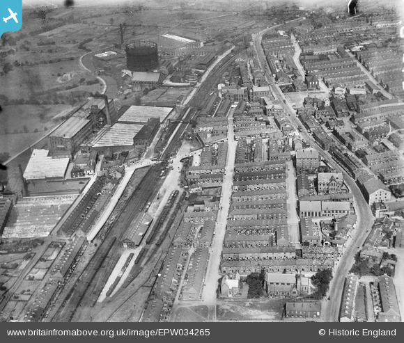
EPW034265 ENGLAND (1930). Sackville Street and environs, Brierfield, 1930
© Copyright OpenStreetMap contributors and licensed by the OpenStreetMap Foundation. 2024. Cartography is licensed as CC BY-SA.
Nearby Images (2)
EPW034265

EPW013256

Details
| Title | [EPW034265] Sackville Street and environs, Brierfield, 1930 |
| Reference | EPW034265 |
| Date | July-1930 |
| Link | |
| Place name | BRIERFIELD |
| Parish | BRIERFIELD |
| District | |
| Country | ENGLAND |
| Easting / Northing | 384560, 436386 |
| Longitude / Latitude | -2.2345776896848, 53.823304420179 |
| National Grid Reference | SD846364 |
Pins
 powerpop |
Monday 16th of July 2018 10:28:17 PM | |
powerpop |
Monday 16th of July 2018 10:27:22 PM | |
powerpop |
Monday 16th of July 2018 10:26:18 PM | |
powerpop |
Monday 16th of July 2018 10:24:51 PM | |
powerpop |
Monday 16th of July 2018 10:24:06 PM | |
powerpop |
Monday 16th of July 2018 10:22:13 PM | |
powerpop |
Monday 16th of July 2018 10:21:49 PM | |
powerpop |
Monday 16th of July 2018 10:20:53 PM | |
powerpop |
Monday 16th of July 2018 10:20:31 PM | |
powerpop |
Monday 16th of July 2018 10:19:08 PM | |
powerpop |
Monday 16th of July 2018 10:18:43 PM | |
powerpop |
Monday 16th of July 2018 10:18:16 PM | |
 Ralph Pomeroy |
Sunday 22nd of April 2018 01:10:50 PM | |
wadey |
Saturday 6th of December 2014 09:45:21 PM | |
wadey |
Monday 6th of October 2014 07:52:15 PM | |
wadey |
Monday 6th of October 2014 07:48:38 PM | |
wadey |
Monday 6th of October 2014 07:47:58 PM | |
wadey |
Monday 6th of October 2014 07:47:05 PM | |
wadey |
Monday 6th of October 2014 07:46:37 PM | |
wadey |
Monday 6th of October 2014 07:44:16 PM | |
wadey |
Monday 6th of October 2014 07:43:31 PM |
User Comment Contributions
Gasometer now a listed structure |
wadey |
Sunday 4th of May 2014 10:58:15 PM |


