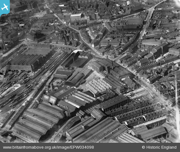
EPW034098 ENGLAND (1930). The Midland Goods Station, the Crown Point Printing Works and St Jude's Church, Pottery Field, 1930
© Copyright OpenStreetMap contributors and licensed by the OpenStreetMap Foundation. 2024. Cartography is licensed as CC BY-SA.
Nearby Images (20)
Details
| Title | [EPW034098] The Midland Goods Station, the Crown Point Printing Works and St Jude's Church, Pottery Field, 1930 |
| Reference | EPW034098 |
| Date | July-1930 |
| Link | |
| Place name | POTTERY FIELD |
| Parish | |
| District | |
| Country | ENGLAND |
| Easting / Northing | 430572, 432588 |
| Longitude / Latitude | -1.5359074609949, 53.788495524526 |
| National Grid Reference | SE306326 |
Pins
 Mick S |
Friday 17th of March 2023 04:24:53 PM | |
 Mick S |
Friday 17th of March 2023 04:24:08 PM | |
 Brick Collector |
Sunday 2nd of February 2014 10:59:20 PM | |
 Brick Collector |
Monday 20th of January 2014 10:29:31 PM | |
 leeds_tyke |
Tuesday 10th of December 2013 08:53:35 AM | |
 leeds_tyke |
Tuesday 10th of December 2013 08:53:31 AM |


![[EPW034098] The Midland Goods Station, the Crown Point Printing Works and St Jude's Church, Pottery Field, 1930](http://britainfromabove.org.uk/sites/all/libraries/aerofilms-images/public/100x100/EPW/034/EPW034098.jpg)
![[EAW038459] The Alf Cooke Ltd Crown Point Printing Works on Hunslet Road, Hunslet, 1951. This image has been produced from a print marked by Aerofilms Ltd for photo editing.](http://britainfromabove.org.uk/sites/all/libraries/aerofilms-images/public/100x100/EAW/038/EAW038459.jpg)
![[EPW034096] The Midland Goods Station, the Crown Point Printing Works and surroundings, Pottery Field, 1930](http://britainfromabove.org.uk/sites/all/libraries/aerofilms-images/public/100x100/EPW/034/EPW034096.jpg)
![[EAW038458] The Alf Cooke Ltd Crown Point Printing Works on Hunslet Road, Hunslet, 1951. This image has been produced from a print marked by Aerofilms Ltd for photo editing.](http://britainfromabove.org.uk/sites/all/libraries/aerofilms-images/public/100x100/EAW/038/EAW038458.jpg)
![[EPW031642] Alfred Cooke's New Crown Point Printing Works, Leeds, 1930](http://britainfromabove.org.uk/sites/all/libraries/aerofilms-images/public/100x100/EPW/031/EPW031642.jpg)
![[EPW034099] The Railway Engineering Works, the Crown Point Printing Works and Hunslet Road, Pottery Field, 1930](http://britainfromabove.org.uk/sites/all/libraries/aerofilms-images/public/100x100/EPW/034/EPW034099.jpg)
![[EPW034095] The Crown Point Printing Works, Globs Mills and the Yorkshire Steel Foundry, Pottery Field, 1930](http://britainfromabove.org.uk/sites/all/libraries/aerofilms-images/public/100x100/EPW/034/EPW034095.jpg)
![[EPW031644] Alfred Cooke's New Crown Point Printing Works, Leeds, 1930](http://britainfromabove.org.uk/sites/all/libraries/aerofilms-images/public/100x100/EPW/031/EPW031644.jpg)
![[EPW031643] Alfred Cooke's New Crown Point Printing Works, Leeds, 1930](http://britainfromabove.org.uk/sites/all/libraries/aerofilms-images/public/100x100/EPW/031/EPW031643.jpg)
![[EPW034097] The Midland Goods Station, the Crown Point Printing Works and St Jude's Church, Pottery Field, 1930](http://britainfromabove.org.uk/sites/all/libraries/aerofilms-images/public/100x100/EPW/034/EPW034097.jpg)
![[EAW038455] The Alf Cooke Ltd Crown Point Printing Works on Hunslet Road and environs, Hunslet, 1951. This image has been produced from a print marked by Aerofilms Ltd for photo editing.](http://britainfromabove.org.uk/sites/all/libraries/aerofilms-images/public/100x100/EAW/038/EAW038455.jpg)
![[EAW038461] The Alf Cooke Ltd Crown Point Printing Works on Hunslet Road, Hunslet, 1951. This image has been produced from a print marked by Aerofilms Ltd for photo editing.](http://britainfromabove.org.uk/sites/all/libraries/aerofilms-images/public/100x100/EAW/038/EAW038461.jpg)
![[EAW038460] The Alf Cooke Ltd Crown Point Printing Works on Hunslet Road and environs, Hunslet, 1951. This image has been produced from a print marked by Aerofilms Ltd for photo editing.](http://britainfromabove.org.uk/sites/all/libraries/aerofilms-images/public/100x100/EAW/038/EAW038460.jpg)
![[EAW015962] Industrial area at Pottery Field, Hunslet, 1948. This image has been produced from a print.](http://britainfromabove.org.uk/sites/all/libraries/aerofilms-images/public/100x100/EAW/015/EAW015962.jpg)
![[EAW038452] The Alf Cooke Ltd Crown Point Printing Works on Hunslet Road and environs, Hunslet, 1951. This image has been produced from a print marked by Aerofilms Ltd for photo editing.](http://britainfromabove.org.uk/sites/all/libraries/aerofilms-images/public/100x100/EAW/038/EAW038452.jpg)
![[EAW015960] Industrial area at Pottery Field, Hunslet, 1948. This image has been produced from a print.](http://britainfromabove.org.uk/sites/all/libraries/aerofilms-images/public/100x100/EAW/015/EAW015960.jpg)
![[EAW015963] Industrial area at Pottery Field, Hunslet, 1948. This image has been produced from a print marked by Aerofilms Ltd for photo editing.](http://britainfromabove.org.uk/sites/all/libraries/aerofilms-images/public/100x100/EAW/015/EAW015963.jpg)
![[EAW015961] Industrial area at Pottery Field, Hunslet, 1948. This image has been produced from a print.](http://britainfromabove.org.uk/sites/all/libraries/aerofilms-images/public/100x100/EAW/015/EAW015961.jpg)
![[EAW015965] Industrial area at Pottery Field, Hunslet, 1948. This image has been produced from a print.](http://britainfromabove.org.uk/sites/all/libraries/aerofilms-images/public/100x100/EAW/015/EAW015965.jpg)
![[EAW015966] Industrial area at Pottery Field, Hunslet, 1948. This image has been produced from a print marked by Aerofilms Ltd for photo editing.](http://britainfromabove.org.uk/sites/all/libraries/aerofilms-images/public/100x100/EAW/015/EAW015966.jpg)


