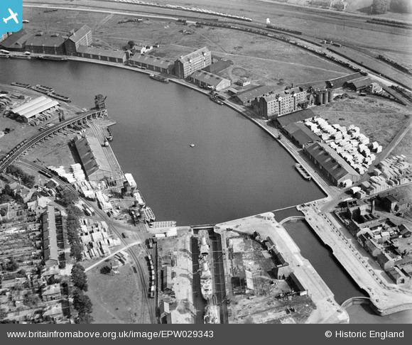
EPW029343 ENGLAND (1929). Canal Basin at Sharpness Docks, Sharpness, 1929
© Copyright OpenStreetMap contributors and licensed by the OpenStreetMap Foundation. 2024. Cartography is licensed as CC BY-SA.
Nearby Images (8)
EPW029343

EPW029346

EAW012141

EPW005401

EAW012140

EAW012138

EPW005400

EAW006849

Details
| Title | [EPW029343] Canal Basin at Sharpness Docks, Sharpness, 1929 |
| Reference | EPW029343 |
| Date | September-1929 |
| Link | |
| Place name | SHARPNESS |
| Parish | HINTON |
| District | |
| Country | ENGLAND |
| Easting / Northing | 367122, 202371 |
| Longitude / Latitude | -2.4759872455805, 51.718642285075 |
| National Grid Reference | SO671024 |
Pins
 MB |
Monday 22nd of August 2016 02:31:17 PM | |
MB |
Monday 22nd of August 2016 02:30:59 PM | |
MB |
Monday 22nd of August 2016 02:30:41 PM | |
MB |
Monday 22nd of August 2016 02:30:14 PM | |
MB |
Monday 22nd of August 2016 02:23:16 PM | |
The rail layout suggests that coal was brought here from the Forest of Dean via the Severn railway bridge |
MB |
Monday 22nd of August 2016 02:32:46 PM |
 Class31 |
Monday 10th of August 2015 08:53:25 AM | |
Class31 |
Monday 10th of August 2015 08:52:09 AM | |
Louis |
Wednesday 12th of November 2014 08:32:08 PM |