
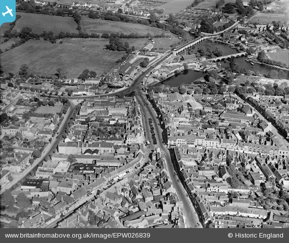
EPW026839 ENGLAND (1929). Bridge Street and environs, Stratford-upon-Avon, 1929
© Copyright OpenStreetMap contributors and licensed by the OpenStreetMap Foundation. 2024. Cartography is licensed as CC BY-SA.
Nearby Images (27)
EPW026839

EPW026837

EPW014647

EPW053206

EAW044238

EPW053209

EPW053210

EAW044239

EPW053204

EPR000580

EAW044237

EPW026838

EAW006663

EPW014650

EPW037593

EAW013455

EPW053202

EPW053203

EPW037628

EAW013452

EPW053205

EPW053208

EPW037591

EAW013453

EPW053207

EAW006662

EPW026842

Details
| Title | [EPW026839] Bridge Street and environs, Stratford-upon-Avon, 1929 |
| Reference | EPW026839 |
| Date | May-1929 |
| Link | |
| Place name | STRATFORD-UPON-AVON |
| Parish | STRATFORD-UPON-AVON |
| District | |
| Country | ENGLAND |
| Easting / Northing | 420255, 254982 |
| Longitude / Latitude | -1.7036548069778, 52.192302159709 |
| National Grid Reference | SP203550 |
Pins
 Fantasma |
Monday 12th of November 2012 09:16:47 PM | |
Fantasma |
Sunday 4th of November 2012 05:08:42 PM | |
Fantasma |
Sunday 4th of November 2012 05:07:55 PM | |
Fantasma |
Sunday 4th of November 2012 05:07:04 PM | |
Fantasma |
Sunday 4th of November 2012 05:06:05 PM | |
Fantasma |
Sunday 4th of November 2012 11:38:20 AM | |
Fantasma |
Sunday 4th of November 2012 11:36:41 AM | |
Fantasma |
Sunday 4th of November 2012 11:33:26 AM | |
Fantasma |
Saturday 20th of October 2012 04:09:13 PM | |
Fantasma |
Saturday 20th of October 2012 04:07:19 PM | |
Fantasma |
Saturday 20th of October 2012 04:05:12 PM | |
Fantasma |
Saturday 20th of October 2012 04:03:58 PM | |
Fantasma |
Saturday 20th of October 2012 04:02:39 PM |


