
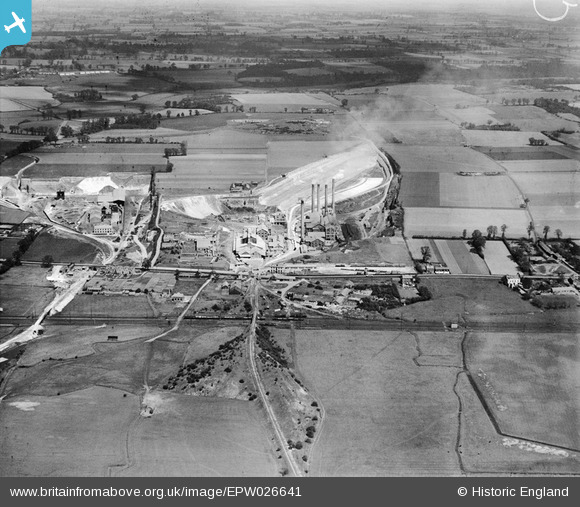
EPW026641 ENGLAND (1929). The Tunnel Portland Cement Works and Thurrock Chalk Quarries, West Thurrock, from the south, 1929
© Copyright OpenStreetMap contributors and licensed by the OpenStreetMap Foundation. 2024. Cartography is licensed as CC BY-SA.
Nearby Images (3)
EPW026641

EPW026636

EPW026645

Details
| Title | [EPW026641] The Tunnel Portland Cement Works and Thurrock Chalk Quarries, West Thurrock, from the south, 1929 |
| Reference | EPW026641 |
| Date | May-1929 |
| Link | |
| Place name | WEST THURROCK |
| Parish | |
| District | |
| Country | ENGLAND |
| Easting / Northing | 557607, 177467 |
| Longitude / Latitude | 0.26962167260913, 51.473695290277 |
| National Grid Reference | TQ576775 |
Pins
 Dylan Moore |
Tuesday 16th of October 2012 05:57:40 PM | |
Dylan Moore |
Tuesday 16th of October 2012 05:57:06 PM |
User Comment Contributions
For details, history and many links, see [[http://www.cementkilns.co.uk/cement_kiln_west_thurrock.html]]. |
Dylan Moore |
Thursday 18th of October 2012 09:33:11 PM |
 Good view of West Thurrock as at 1929. |
Dylan Moore |
Tuesday 16th of October 2012 06:56:57 PM |
The West Thurrock Plant of the Tunnel Portland Cement Company Ltd. The plant began in a small way in 1874, but became much more significant when it was acquired by the Danish firm F L Smidth in 1911, when it was rebuilt on up-to-date lines and rapidly expanded. By the time of the photograph, the original two rotary kilns had increased to four, and a further three were installed before WWII. By 1938 it was the largest British plant, and remained so until 1970. It closed in 1976. The Tunnel name was derived from Tunnel Farm, which still stood at this time, on the top of the quarry face behind the plant. |
Dylan Moore |
Tuesday 16th of October 2012 05:58:28 PM |


