
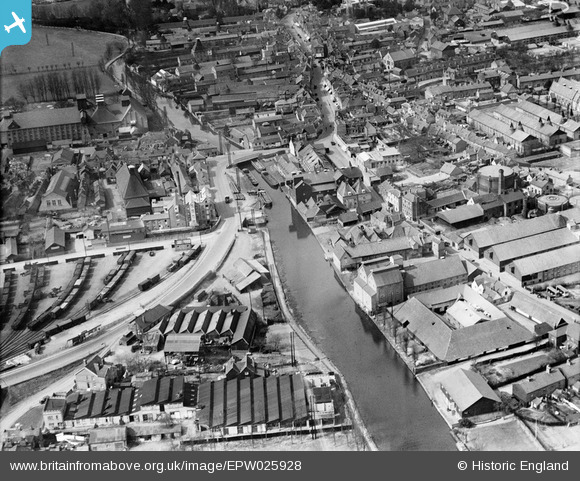
EPW025928 ENGLAND (1929). Works and wharfage on the River Lee, Ware, 1929
© Copyright OpenStreetMap contributors and licensed by the OpenStreetMap Foundation. 2024. Cartography is licensed as CC BY-SA.
Nearby Images (8)
EPW025928

EAW022365

EAW049501

EPW025936

EAW022366

EPW025934

EPW025932

EPW013338

Details
| Title | [EPW025928] Works and wharfage on the River Lee, Ware, 1929 |
| Reference | EPW025928 |
| Date | 3-April-1929 |
| Link | |
| Place name | WARE |
| Parish | WARE |
| District | |
| Country | ENGLAND |
| Easting / Northing | 536062, 214148 |
| Longitude / Latitude | -0.026158887085226, 51.808939769198 |
| National Grid Reference | TL361141 |
Pins
 John W |
Wednesday 3rd of August 2016 07:14:42 PM | |
John1949 |
Tuesday 12th of August 2014 06:31:56 PM | |
John1949 |
Tuesday 12th of August 2014 06:29:42 PM | |
John1949 |
Tuesday 12th of August 2014 06:27:18 PM | |
 Class31 |
Monday 26th of May 2014 09:20:16 PM | |
Grk |
Sunday 26th of January 2014 04:23:34 PM | |
Nick G |
Sunday 20th of October 2013 08:22:35 PM | |
wazzer |
Thursday 6th of September 2012 09:50:55 AM | |
wazzer |
Thursday 6th of September 2012 09:41:46 AM | |
wazzer |
Thursday 6th of September 2012 09:38:32 AM | |
wazzer |
Thursday 6th of September 2012 09:38:01 AM | |
wazzer |
Thursday 6th of September 2012 09:35:41 AM | |
wazzer |
Thursday 6th of September 2012 09:34:50 AM | |
wazzer |
Thursday 6th of September 2012 09:33:27 AM | |
wazzer |
Thursday 6th of September 2012 09:31:41 AM | |
SteveAUS |
Friday 31st of August 2012 05:53:51 AM |


