
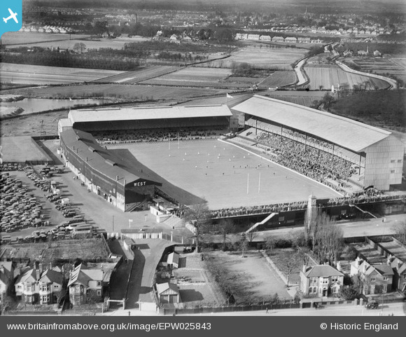
EPW025843 ENGLAND (1929). Twickenham, the annual Army Navy rugby union match, 1929
© Copyright OpenStreetMap contributors and licensed by the OpenStreetMap Foundation. 2024. Cartography is licensed as CC BY-SA.
Nearby Images (22)
EPW025843

EPW025840

EPW022945

EPW025839

EPW025841

EPW049454

EPW049453

EPW049455

EPW049447

EPR000638

EPW025842

EPW023249

EPW049446

EPW025845

EPW049452

EPW025844

EPW049449

EPW017385

EPW049451

EPW049450

EPW049448

EPW034843

Details
| Title | [EPW025843] Twickenham, the annual Army Navy rugby union match, 1929 |
| Reference | EPW025843 |
| Date | 23-March-1929 |
| Link | |
| Place name | TWICKENHAM |
| Parish | |
| District | |
| Country | ENGLAND |
| Easting / Northing | 515328, 174327 |
| Longitude / Latitude | -0.33991698592641, 51.455672035632 |
| National Grid Reference | TQ153743 |
Pins
 MB |
Thursday 25th of October 2012 11:34:29 PM | |
MB |
Thursday 25th of October 2012 11:31:43 PM | |
MB |
Thursday 25th of October 2012 11:30:50 PM | |
MB |
Thursday 25th of October 2012 11:29:58 PM |


