
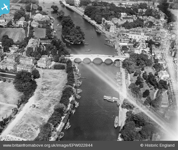
EPW022844 ENGLAND (1928). Richmond Bridge, Richmond, 1928
© Copyright OpenStreetMap contributors and licensed by the OpenStreetMap Foundation. 2024. Cartography is licensed as CC BY-SA.
Nearby Images (25)
EPW022844

EPW022837

EAW026799

EPW022838

EPW044552

EAW008242

EAW042759

EPW001695

EAW042758

EPW001693

EAW042757

EPW056173

EPW008871

EAW026798

EPW001694

EAW036494

EPW001696

EAW036500

EAW036493

EAW036497

EAW036495

EPW031987

EPW031992

EPW036445

EAW015165

Details
| Title | [EPW022844] Richmond Bridge, Richmond, 1928 |
| Reference | EPW022844 |
| Date | August-1928 |
| Link | |
| Place name | RICHMOND |
| Parish | |
| District | |
| Country | ENGLAND |
| Easting / Northing | 517728, 174485 |
| Longitude / Latitude | -0.30533378480875, 51.456598146463 |
| National Grid Reference | TQ177745 |
Pins
Be the first to add a comment to this image!
User Comment Contributions
 Richmond upon Thames |
 Alan McFaden |
Thursday 4th of December 2014 10:05:15 AM |


