
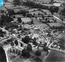
EPW022423 ENGLAND (1928). The Town Centre, Fairford, 1928

© Copyright OpenStreetMap contributors and licensed by the OpenStreetMap Foundation. 2024. Cartography is licensed as CC BY-SA.
Nearby Images (4)
EPW022423

EPW022422

EPW022420

EPW022419

Details
| Title | [EPW022423] The Town Centre, Fairford, 1928 |
| Reference | EPW022423 |
| Date | August-1928 |
| Link | |
| Place name | FAIRFORD |
| Parish | FAIRFORD |
| District | |
| Country | ENGLAND |
| Easting / Northing | 415268, 200990 |
| Longitude / Latitude | -1.7790166893257, 51.706980280831 |
| National Grid Reference | SP153010 |
Pins
 Eagle eye |
Sunday 8th of February 2015 05:34:13 PM | |
Lynda Tubbs |
Thursday 16th of January 2014 12:08:33 PM | |
Lynda Tubbs |
Thursday 16th of January 2014 12:04:31 PM | |
Lynda Tubbs |
Thursday 16th of January 2014 11:55:52 AM | |
Lynda Tubbs |
Thursday 16th of January 2014 11:55:21 AM | |
Lynda Tubbs |
Wednesday 5th of June 2013 03:07:01 PM |
User Comment Contributions
 There are very clear images of Fairford. |
Lynda Tubbs |
Tuesday 29th of July 2014 02:44:23 PM |
View of Fairford from the north west |
Hefin Meara |
Tuesday 22nd of January 2013 11:51:00 AM |


