
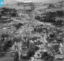
EPW022414 ENGLAND (1928). The Town Centre, Cirencester, from the south-east, 1928

© Copyright OpenStreetMap contributors and licensed by the OpenStreetMap Foundation. 2024. Cartography is licensed as CC BY-SA.
Nearby Images (5)
EPW022414

EAW006876

EPW022409

EAW031678

EAW006878

Details
| Title | [EPW022414] The Town Centre, Cirencester, from the south-east, 1928 |
| Reference | EPW022414 |
| Date | August-1928 |
| Link | |
| Place name | CIRENCESTER |
| Parish | CIRENCESTER |
| District | |
| Country | ENGLAND |
| Easting / Northing | 402514, 201680 |
| Longitude / Latitude | -1.9636081854375, 51.713387051611 |
| National Grid Reference | SP025017 |
Pins
 MB |
Tuesday 25th of September 2018 08:49:16 PM | |
 Class31 |
Thursday 24th of January 2013 08:43:23 PM | |
Class31 |
Thursday 24th of January 2013 08:42:56 PM | |
Class31 |
Thursday 24th of January 2013 08:42:04 PM | |
Class31 |
Thursday 24th of January 2013 08:41:02 PM | |
Class31 |
Thursday 24th of January 2013 08:39:53 PM | |
Class31 |
Thursday 24th of January 2013 08:38:18 PM | |
Class31 |
Thursday 24th of January 2013 08:37:42 PM | |
Class31 |
Friday 5th of October 2012 09:04:03 PM | |
Tetbury |
Wednesday 27th of June 2012 09:46:45 PM |
User Comment Contributions
 Cirencester |
Hefin Meara |
Tuesday 22nd of January 2013 12:10:15 PM |
from the south, surely? |
egide |
Wednesday 7th of November 2012 09:15:43 AM |
Dear Egide, Thank you for the comment - the lovely straight Roman road is Ermin Street heading off towards Gloucester, so I'm going to adjust the caption to say 'from the south-east'. Best wishes Laura Maddison |
 Laura Maddison |
Wednesday 7th of November 2012 09:15:43 AM |


