
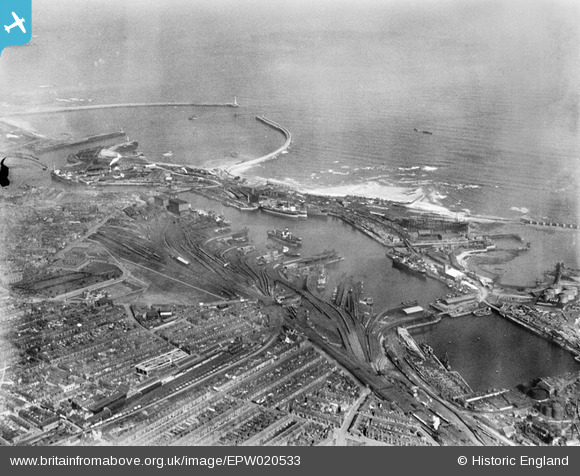
EPW020533 ENGLAND (1928). Hendon and Hudson Docks and the harbour entrance, Sunderland, 1928
© Copyright OpenStreetMap contributors and licensed by the OpenStreetMap Foundation. 2024. Cartography is licensed as CC BY-SA.
Nearby Images (22)
EPW020533

EAW003179

EAW003173

EAW003175

EPW020539

EAW003178

EAW003174

EAW003172

EAW003181

EAW003177

EPW020537

EPW020536

EAW003180

EAW001017

EAW001015

EAW003184

EAW003183

EAW003171

EAW003176

EPW020531

EPW051128

EAW003182

Details
| Title | [EPW020533] Hendon and Hudson Docks and the harbour entrance, Sunderland, 1928 |
| Reference | EPW020533 |
| Date | March-1928 |
| Link | |
| Place name | SUNDERLAND |
| Parish | |
| District | |
| Country | ENGLAND |
| Easting / Northing | 441195, 557408 |
| Longitude / Latitude | -1.3573886291519, 54.909600081928 |
| National Grid Reference | NZ412574 |
Pins
 Piglet1 |
Sunday 29th of October 2023 05:44:25 PM | |
jeffsafc |
Sunday 10th of September 2017 05:08:44 PM | |
jeffsafc |
Sunday 10th of September 2017 05:06:50 PM | |
jeffsafc |
Sunday 10th of September 2017 05:01:49 PM | |
kevin n |
Friday 3rd of January 2014 01:09:00 PM | |
 John Swain |
Monday 19th of August 2013 11:45:34 AM | |
John Swain |
Monday 19th of August 2013 11:42:35 AM | |
John Swain |
Monday 19th of August 2013 11:41:40 AM | |
John Swain |
Monday 19th of August 2013 11:40:30 AM | |
John Swain |
Monday 19th of August 2013 11:39:33 AM | |
John Swain |
Monday 19th of August 2013 11:38:22 AM | |
John Swain |
Monday 19th of August 2013 11:36:39 AM | |
John Swain |
Monday 19th of August 2013 11:34:58 AM | |
John Swain |
Monday 19th of August 2013 11:33:04 AM | |
John Swain |
Monday 19th of August 2013 11:31:33 AM | |
John Swain |
Monday 19th of August 2013 11:30:04 AM | |
John Swain |
Monday 19th of August 2013 11:29:20 AM | |
John Swain |
Monday 19th of August 2013 11:28:27 AM | |
John Swain |
Monday 19th of August 2013 11:27:47 AM | |
John Swain |
Monday 19th of August 2013 11:27:05 AM | |
John Swain |
Monday 19th of August 2013 11:26:21 AM |
User Comment Contributions
The Hudson and Hendon Docks were created on the south side of the Wear Estuary in the 1850s for the large-scale export of coal from the local collieries. The Seaham & Sunderland Railway was opened in 1854 and it thrived on coal shipments, like most of the railways built in the mid-19th century in North East England. Shipbuilding and coal exports formed the basis of Sunderland's prosperity from the 1850s, as the town grew to 146,000 in 1901 (close to 185,000 at the time this picture was taken), and some of the compact street patterns of terraced housing are still intact. Since the 1980s, Sunderland has been a city (1992) in transition: a marina, service industries and new university buildings are replacing the old shipyards, coal docks and staithes. The Stadium of Light, home of Sunderland AFC, occupies the site of the former Wearmouth Colliery. |
John Swain |
Monday 19th of August 2013 12:05:12 PM |


