
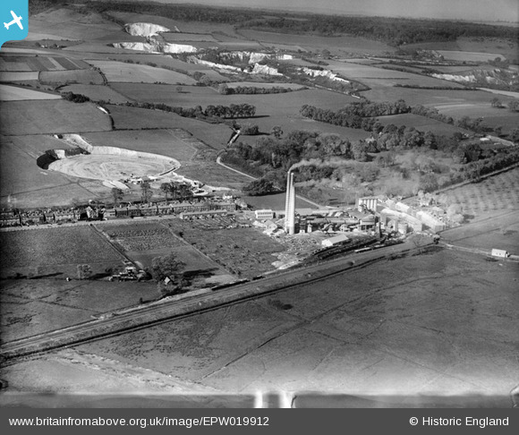
EPW019912 ENGLAND (1927). Holborough Cement Works and Quarry, Holborough, 1927
© Copyright OpenStreetMap contributors and licensed by the OpenStreetMap Foundation. 2024. Cartography is licensed as CC BY-SA.
Nearby Images (19)
EPW019912

EPW020918

EPW020925

EPW020919

EPW020920

EPW020921

EPW019911

EPW019902

EPW020923

EPW019904

EPW019909

EPW019903

EPW019901

EPW019906

EPW020922

EPW020924

EPW019908

EPW019907

EPW019910

Details
| Title | [EPW019912] Holborough Cement Works and Quarry, Holborough, 1927 |
| Reference | EPW019912 |
| Date | October-1927 |
| Link | |
| Place name | HOLBOROUGH |
| Parish | SNODLAND |
| District | |
| Country | ENGLAND |
| Easting / Northing | 570430, 162567 |
| Longitude / Latitude | 0.44694550035064, 51.336109820806 |
| National Grid Reference | TQ704626 |
Pins
 Dylan Moore |
Tuesday 15th of July 2014 01:06:05 AM | |
Dylan Moore |
Tuesday 15th of July 2014 01:05:34 AM | |
Dylan Moore |
Tuesday 15th of July 2014 12:36:09 AM | |
Dylan Moore |
Tuesday 15th of July 2014 12:35:37 AM | |
Dylan Moore |
Tuesday 15th of July 2014 12:34:51 AM | |
Dylan Moore |
Tuesday 15th of July 2014 12:34:15 AM | |
Dylan Moore |
Tuesday 16th of October 2012 11:49:56 AM |
User Comment Contributions
Picture of Holborough Cement Plant just before its acquisition by the Red Triangle Group. The plant operated 1924-1984. The third kiln had been installed the previous year. |
Dylan Moore |
Tuesday 16th of October 2012 11:48:09 AM |


