
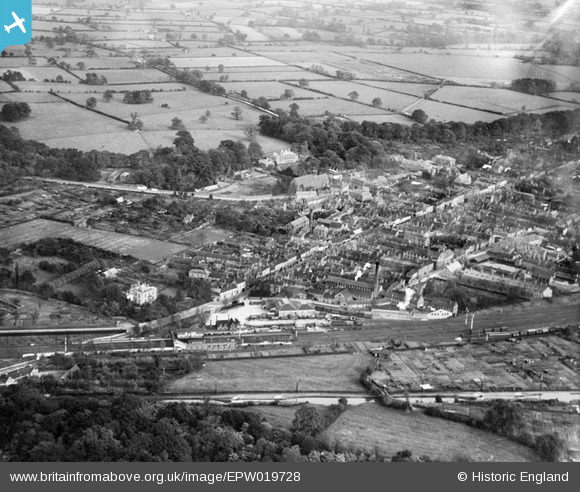
EPW019728 ENGLAND (1927). The Railway Station and town, Atherstone, from the south-west, 1927
© Copyright OpenStreetMap contributors and licensed by the OpenStreetMap Foundation. 2024. Cartography is licensed as CC BY-SA.
Nearby Images (5)
EPW019728

EPW019727

EPW021028

EPW021027

EPW019726

Details
| Title | [EPW019728] The Railway Station and town, Atherstone, from the south-west, 1927 |
| Reference | EPW019728 |
| Date | October-1927 |
| Link | |
| Place name | ATHERSTONE |
| Parish | ATHERSTONE |
| District | |
| Country | ENGLAND |
| Easting / Northing | 430562, 297901 |
| Longitude / Latitude | -1.5489444521505, 52.577706529089 |
| National Grid Reference | SP306979 |
Pins
 RH |
Tuesday 22nd of July 2014 01:10:22 PM | |
MB |
Friday 12th of October 2012 10:45:53 AM | |
MB |
Friday 12th of October 2012 10:42:29 AM | |
MB |
Friday 12th of October 2012 10:39:13 AM | |
MB |
Friday 12th of October 2012 10:28:06 AM | |
MB |
Friday 12th of October 2012 10:27:06 AM | |
MB |
Friday 12th of October 2012 10:25:03 AM | |
MB |
Friday 12th of October 2012 10:24:20 AM | |
MB |
Friday 12th of October 2012 10:23:49 AM | |
MB |
Friday 12th of October 2012 10:22:32 AM | |
MB |
Friday 12th of October 2012 10:21:54 AM | |
MB |
Friday 12th of October 2012 10:21:31 AM | |
MB |
Friday 12th of October 2012 10:20:38 AM | |
MB |
Friday 12th of October 2012 10:19:48 AM | |
MB |
Friday 12th of October 2012 10:19:12 AM | |
MB |
Friday 12th of October 2012 10:18:10 AM | |
MB |
Friday 12th of October 2012 10:17:05 AM | |
MB |
Friday 12th of October 2012 10:15:46 AM | |
MB |
Friday 12th of October 2012 10:15:25 AM | |
MB |
Friday 12th of October 2012 10:14:57 AM | |
MB |
Friday 12th of October 2012 10:11:33 AM | |
MB |
Friday 12th of October 2012 10:11:09 AM |
User Comment Contributions
Apparently the canal company had run out of money when the canal reached Atherstone from Coventry in 1771. The canal and the locks seen here were extended to Fazeley in 1790 |
MB |
Friday 12th of October 2012 10:32:05 AM |
Looking roughly east north east, or north east |
MB |
Friday 12th of October 2012 10:26:20 AM |


