
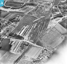
EPW018652 ENGLAND (1927). Ramsgate Station and sidings, Ramsgate, 1927

© Copyright OpenStreetMap contributors and licensed by the OpenStreetMap Foundation. 2024. Cartography is licensed as CC BY-SA.
Details
| Title | [EPW018652] Ramsgate Station and sidings, Ramsgate, 1927 |
| Reference | EPW018652 |
| Date | 22-June-1927 |
| Link | |
| Place name | RAMSGATE |
| Parish | RAMSGATE |
| District | |
| Country | ENGLAND |
| Easting / Northing | 637083, 165729 |
| Longitude / Latitude | 1.4044612158847, 51.340618354989 |
| National Grid Reference | TR371657 |
Pins
 mike |
Tuesday 18th of August 2015 09:22:24 PM | |
John Russell |
Saturday 30th of June 2012 09:07:52 PM | |
John Russell |
Saturday 30th of June 2012 09:00:20 PM | |
John Russell |
Saturday 30th of June 2012 08:52:27 PM | |
John Russell |
Saturday 30th of June 2012 08:49:46 PM | |
John Russell |
Saturday 30th of June 2012 08:49:11 PM | |
John Russell |
Saturday 30th of June 2012 08:48:26 PM | |
John Russell |
Saturday 30th of June 2012 08:47:32 PM | |
John Russell |
Saturday 30th of June 2012 08:44:22 PM | |
jim greaves |
Saturday 26th of May 2012 09:03:24 AM | |
jim greaves |
Saturday 26th of May 2012 09:02:33 AM | |
jim greaves |
Saturday 26th of May 2012 09:01:33 AM | |
jim greaves |
Saturday 26th of May 2012 09:00:25 AM | |
jim greaves |
Saturday 26th of May 2012 08:59:28 AM | |
jim greaves |
Saturday 26th of May 2012 08:57:43 AM |
User Comment Contributions
 Ramsgate Station |
John Russell |
Saturday 30th of June 2012 08:42:23 PM |


