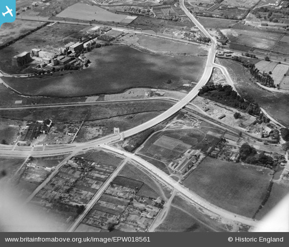
EPW018561 ENGLAND (1927). The Lea Valley Viaduct, Chingford, 1927
© Copyright OpenStreetMap contributors and licensed by the OpenStreetMap Foundation. 2024. Cartography is licensed as CC BY-SA.
Nearby Images (25)
Details
| Title | [EPW018561] The Lea Valley Viaduct, Chingford, 1927 |
| Reference | EPW018561 |
| Date | June-1927 |
| Link | |
| Place name | CHINGFORD |
| Parish | |
| District | |
| Country | ENGLAND |
| Easting / Northing | 536257, 192185 |
| Longitude / Latitude | -0.031919775843663, 51.611514045583 |
| National Grid Reference | TQ363922 |
Pins
User Comment Contributions
Cross Keys Pub |
 SilentFart |
Tuesday 26th of June 2012 03:16:40 PM |
 Now looks like this. |
 SilentFart |
Tuesday 26th of June 2012 03:04:39 PM |


![[EPW018561] The Lea Valley Viaduct, Chingford, 1927](http://britainfromabove.org.uk/sites/all/libraries/aerofilms-images/public/100x100/EPW/018/EPW018561.jpg)
![[EPW018563] The Lea Valley Viaduct, Chingford, 1927](http://britainfromabove.org.uk/sites/all/libraries/aerofilms-images/public/100x100/EPW/018/EPW018563.jpg)
![[EPW018562] The Lea Valley Viaduct, Chingford, 1927](http://britainfromabove.org.uk/sites/all/libraries/aerofilms-images/public/100x100/EPW/018/EPW018562.jpg)
![[EPW018569] The Lea Valley Viaduct, Chingford, 1927](http://britainfromabove.org.uk/sites/all/libraries/aerofilms-images/public/100x100/EPW/018/EPW018569.jpg)
![[EPW018572] The Lea Valley Viaduct, Chingford, 1927](http://britainfromabove.org.uk/sites/all/libraries/aerofilms-images/public/100x100/EPW/018/EPW018572.jpg)
![[EPW018564] The Lea Valley Viaduct, Chingford, 1927](http://britainfromabove.org.uk/sites/all/libraries/aerofilms-images/public/100x100/EPW/018/EPW018564.jpg)
![[EPW018568] The Lea Valley Viaduct and environs, Chingford, 1927](http://britainfromabove.org.uk/sites/all/libraries/aerofilms-images/public/100x100/EPW/018/EPW018568.jpg)
![[EPW056818] The junction of Lower Hall Lane and the North Circular Road, Edmonton, 1938](http://britainfromabove.org.uk/sites/all/libraries/aerofilms-images/public/100x100/EPW/056/EPW056818.jpg)
![[EPW053837] The North Circular Road and the River Lea, Edmonton, 1937](http://britainfromabove.org.uk/sites/all/libraries/aerofilms-images/public/100x100/EPW/053/EPW053837.jpg)
![[EPW018656] The Lea Valley Viaduct and environs, Chingford, 1927](http://britainfromabove.org.uk/sites/all/libraries/aerofilms-images/public/100x100/EPW/018/EPW018656.jpg)
![[EAW037671] The London Rubber Company (British Latex Products) Factory, Flexo Plywood Works and the Cork Manufacturing Co Ltd Langite Works off Hall Lane, Chingford, 1951. This image has been produced from a print marked by Aerofilms Ltd for photo editing](http://britainfromabove.org.uk/sites/all/libraries/aerofilms-images/public/100x100/EAW/037/EAW037671.jpg)
![[EAW037670] The London Rubber Company (British Latex Products) Factory, Flexo Plywood Works and the Cork Manufacturing Co Ltd Langite Works off Hall Lane, Chingford, 1951. This image has been produced from a print marked by Aerofilms Ltd for photo editing](http://britainfromabove.org.uk/sites/all/libraries/aerofilms-images/public/100x100/EAW/037/EAW037670.jpg)
![[EAW037672] The London Rubber Company (British Latex Products) Factory and the Cork Manufacturing Co Ltd Langite Works off Hall Lane, Chingford, 1951. This image has been produced from a print marked by Aerofilms Ltd for photo editing.](http://britainfromabove.org.uk/sites/all/libraries/aerofilms-images/public/100x100/EAW/037/EAW037672.jpg)
![[EAW037675] The London Rubber Company (British Latex Products) Factory and the Cork Manufacturing Co Ltd Langite Works off Hall Lane, Chingford, 1951. This image has been produced from a print marked by Aerofilms Ltd for photo editing.](http://britainfromabove.org.uk/sites/all/libraries/aerofilms-images/public/100x100/EAW/037/EAW037675.jpg)
![[EAW037673] The London Rubber Company (British Latex Products) Factory and the Cork Manufacturing Co Ltd Langite Works off Hall Lane, Chingford, 1951. This image has been produced from a print marked by Aerofilms Ltd for photo editing.](http://britainfromabove.org.uk/sites/all/libraries/aerofilms-images/public/100x100/EAW/037/EAW037673.jpg)
![[EPW052282] The junction of Lower Hall Lane and the North Circular Road, Edmonton, 1936. This image has been produced from a damaged negative.](http://britainfromabove.org.uk/sites/all/libraries/aerofilms-images/public/100x100/EPW/052/EPW052282.jpg)
![[EPW056816] The junction of the North Circular Road and Lower Hall Lane, Edmonton, 1938](http://britainfromabove.org.uk/sites/all/libraries/aerofilms-images/public/100x100/EPW/056/EPW056816.jpg)
![[EAW037674] The London Rubber Company (British Latex Products) Factory and the Cork Manufacturing Co Ltd Langite Works off Hall Lane, Chingford, 1951. This image has been produced from a print marked by Aerofilms Ltd for photo editing.](http://britainfromabove.org.uk/sites/all/libraries/aerofilms-images/public/100x100/EAW/037/EAW037674.jpg)
![[EPW058457] The North Circular Road Crossing the River Lea, Edmonton, 1938](http://britainfromabove.org.uk/sites/all/libraries/aerofilms-images/public/100x100/EPW/058/EPW058457.jpg)
![[EPW056823] The junction of Lower Hall Lane and the North Circular Road, Edmonton, 1938](http://britainfromabove.org.uk/sites/all/libraries/aerofilms-images/public/100x100/EPW/056/EPW056823.jpg)
![[EPW018570] The Lea Valley Viaduct, Chingford, 1927](http://britainfromabove.org.uk/sites/all/libraries/aerofilms-images/public/100x100/EPW/018/EPW018570.jpg)
![[EPW052271] The junction of Lower Hall Lane and the North Circular Road, Edmonton, 1936. This image has been produced from a damaged negative.](http://britainfromabove.org.uk/sites/all/libraries/aerofilms-images/public/100x100/EPW/052/EPW052271.jpg)
![[EAW037676] The London Rubber Company (British Latex Products) Factory and the Cork Manufacturing Co Ltd Langite Works off Hall Lane, Chingford, 1951. This image has been produced from a print marked by Aerofilms Ltd for photo editing.](http://britainfromabove.org.uk/sites/all/libraries/aerofilms-images/public/100x100/EAW/037/EAW037676.jpg)
![[EPW056321] The junction of the North Circular Road and Lower Hall Lane, Edmonton, 1938](http://britainfromabove.org.uk/sites/all/libraries/aerofilms-images/public/100x100/EPW/056/EPW056321.jpg)
![[EPW053853] The North Orbital Road, River Lea and the Angel Factory Colony, Edmonton, 1937](http://britainfromabove.org.uk/sites/all/libraries/aerofilms-images/public/100x100/EPW/053/EPW053853.jpg)


