
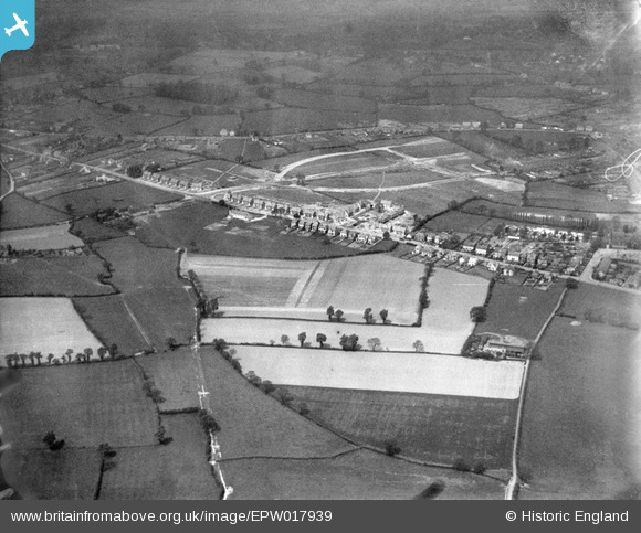
EPW017939 ENGLAND (1927). Coalway Road and the Oxbarn Avenue housing estate under construction, Merry Hill, 1927
© Copyright OpenStreetMap contributors and licensed by the OpenStreetMap Foundation. 2024. Cartography is licensed as CC BY-SA.
Nearby Images (9)
EPW017939

EPW017942

EPW017944

EPW017948

EPW017947

EPW017945

EPW017943

EPW017946

EPW017941

Details
| Title | [EPW017939] Coalway Road and the Oxbarn Avenue housing estate under construction, Merry Hill, 1927 |
| Reference | EPW017939 |
| Date | 11-May-1927 |
| Link | |
| Place name | MERRY HILL |
| Parish | |
| District | |
| Country | ENGLAND |
| Easting / Northing | 389245, 296775 |
| Longitude / Latitude | -2.1586956647614, 52.568335455058 |
| National Grid Reference | SO892968 |
Pins
 Class31 |
Friday 9th of November 2012 08:51:13 PM | |
Class31 |
Friday 9th of November 2012 08:50:46 PM | |
Class31 |
Friday 9th of November 2012 08:49:56 PM | |
 Sligs |
Friday 13th of July 2012 11:30:56 PM | |
Sligs |
Friday 13th of July 2012 11:15:47 PM | |
Sligs |
Friday 13th of July 2012 10:35:51 PM | |
Sligs |
Friday 13th of July 2012 10:34:02 PM | |
Sligs |
Friday 13th of July 2012 10:32:34 PM | |
johnabutt |
Friday 6th of July 2012 09:54:02 PM | |
This site eventually became the school but in the photo it's the main Oxbarn farm estate. The owner (Isaac Saredon Sparrow, son of John William Sparrow) sold off the nearby land a few years after this photo was taken to builders who began constructing the houses that exist there today. |
Sligs |
Friday 13th of July 2012 11:14:44 PM |
johnabutt |
Friday 6th of July 2012 09:53:16 PM | |
It is. If you compare the modern day photos from Google maps you'll see the whole Oxbarn estate being formed. The eventually join it to Trysull Road but in the 1927 photo you can see the Gunmakers pub is there on the corner. |
Sligs |
Friday 13th of July 2012 11:08:48 PM |
johnabutt |
Friday 6th of July 2012 09:52:47 PM | |
It is. However, in 1927 it was called Coalway Lane |
Sligs |
Friday 13th of July 2012 11:06:21 PM |


