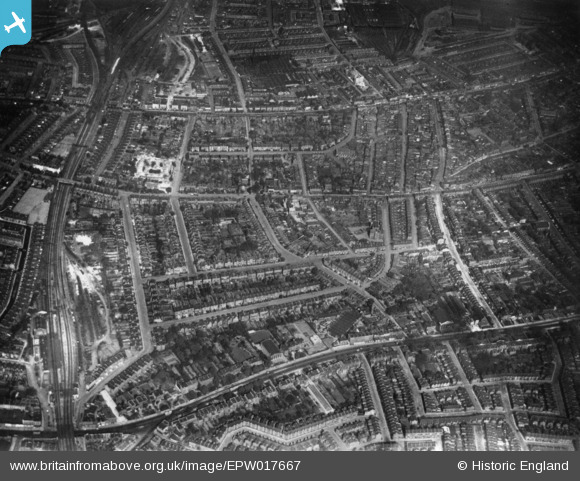
EPW017667 ENGLAND (1927). Bromfelde Road and environs, South Lambeth, 1927. This image has been produced from a print.
© Copyright OpenStreetMap contributors and licensed by the OpenStreetMap Foundation. 2024. Cartography is licensed as CC BY-SA.
Nearby Images (6)
EPW017667

EAW030135

EPW022807

EPW017666

EPW022820

EPW017169

Details
| Title | [EPW017667] Bromfelde Road and environs, South Lambeth, 1927. This image has been produced from a print. |
| Reference | EPW017667 |
| Date | April-1927 |
| Link | |
| Place name | SOUTH LAMBETH |
| Parish | |
| District | |
| Country | ENGLAND |
| Easting / Northing | 529902, 176201 |
| Longitude / Latitude | -0.12955703057514, 51.469358195204 |
| National Grid Reference | TQ299762 |
Pins
 1IG |
Friday 16th of October 2015 07:47:13 PM | |
1IG |
Friday 19th of June 2015 02:33:05 AM | |
1IG |
Thursday 18th of June 2015 11:28:46 AM | |
1IG |
Thursday 18th of June 2015 11:28:42 AM | |
 Class31 |
Friday 21st of November 2014 02:13:39 PM | |
Class31 |
Friday 31st of October 2014 08:54:35 PM | |
Class31 |
Friday 31st of October 2014 08:52:00 PM | |
Class31 |
Friday 31st of October 2014 08:48:41 PM |