
EPW016008 ENGLAND (1926). Horticultural plots, Wickhambrook, 1926

© Copyright OpenStreetMap contributors and licensed by the OpenStreetMap Foundation. 2024. Cartography is licensed as CC BY-SA.
Nearby Images (7)
EPW016008

EPW016011

EPW016006

EPW016009

EPW016005

EPW016010

EPW016004

Details
| Title | [EPW016008] Horticultural plots, Wickhambrook, 1926 |
| Reference | EPW016008 |
| Date | 1-July-1926 |
| Link | |
| Place name | WICKHAMBROOK |
| Parish | WICKHAMBROOK |
| District | |
| Country | ENGLAND |
| Easting / Northing | 574236, 256569 |
| Longitude / Latitude | 0.54866581221678, 52.179411233735 |
| National Grid Reference | TL742566 |
Pins
 nkingdon |
Tuesday 12th of November 2013 09:07:48 PM | |
 Class31 |
Monday 15th of October 2012 10:29:32 PM | |
Class31 |
Monday 15th of October 2012 10:26:46 PM | |
Class31 |
Monday 15th of October 2012 09:31:15 PM | |
All bu tone tree has been grubbed up and is now an arable field |
nkingdon |
Tuesday 12th of November 2013 09:37:57 PM |
Class31 |
Monday 15th of October 2012 09:30:39 PM | |
Leads to Badmondisfield Hall |
nkingdon |
Tuesday 12th of November 2013 09:10:27 PM |
John New |
Sunday 8th of July 2012 11:01:44 PM |
User Comment Contributions
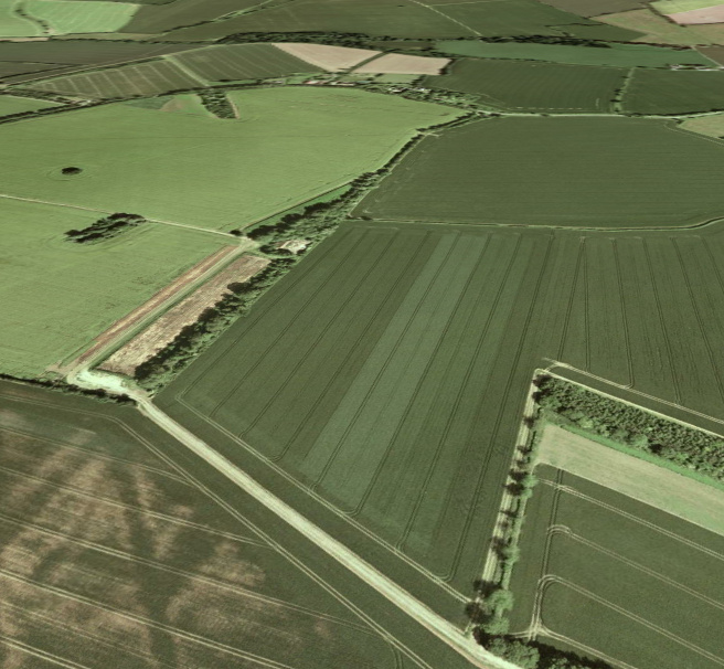 Hurrah, my first find! It is north of Wickhambrook between The Gesyns and Badmondisfield Hall. This photograph is taken looking eastwards. |
nkingdon |
Wednesday 8th of January 2014 09:03:18 AM |
Very well done with these nkingdon, it's taken so long to get this location - makes it even more pleasing finally to identify the images! We'll update the catalogue and post the new data here in due course. Yours, Katy Britain from Above Cataloguing Team Leader |
Katy Whitaker |
Wednesday 8th of January 2014 09:03:18 AM |
Another mystery solved. Excellent work nkingdon |
Class31 |
Tuesday 12th of November 2013 11:10:36 PM |
Is this an agricultural station? It looks like there are many different field trials taking place in the main filed in the middle of the photo. |
Rebecca |
Thursday 10th of January 2013 02:01:29 PM |
Can I ask if there is any evidence for the Great Linford location? I've looked at Great Linford and can't find anything to link it with this and the other photos. As an aside there is a crop mark in the picture above bottom left. Does it mark anything significant? |
Class31 |
Tuesday 23rd of October 2012 03:34:44 PM |
Hi Class 31, I've had a look again at this and the others in the run. I can't fit the field boundaries to Great Linford, so we need someone else to make a different suggestion! Yours, Katy Britain from Above Cataloguing Team Leader |
Katy Whitaker |
Tuesday 23rd of October 2012 03:34:44 PM |
Could be Rothampsted Manor,Hertfordshire |
GWRMAD |
Thursday 28th of June 2012 02:54:09 PM |
Also see EPW016004, EPW016005,EPW016006 and EPW016009, EPW016010, EPW016011 |
co_fragment |
Wednesday 27th of June 2012 06:05:56 PM |
This looks like a set of field trials |
Dr John |
Wednesday 27th of June 2012 01:47:49 PM |
This picture and EPW016011 are of the same location. |
co_fragment |
Tuesday 26th of June 2012 08:04:14 PM |


