
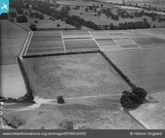
EPW016005 ENGLAND (1926). Horticultural plots, Wickhambrook, 1926
© Copyright OpenStreetMap contributors and licensed by the OpenStreetMap Foundation. 2024. Cartography is licensed as CC BY-SA.
Nearby Images (5)
EPW016005

EPW016008

EPW016011

EPW016006

EPW016009

Details
| Title | [EPW016005] Horticultural plots, Wickhambrook, 1926 |
| Reference | EPW016005 |
| Date | 1-July-1926 |
| Link | |
| Place name | WICKHAMBROOK |
| Parish | WICKHAMBROOK |
| District | |
| Country | ENGLAND |
| Easting / Northing | 574163, 256439 |
| Longitude / Latitude | 0.54753237486282, 52.178266550982 |
| National Grid Reference | TL742564 |
Pins
 nkingdon |
Tuesday 12th of November 2013 10:00:08 PM | |
nkingdon |
Tuesday 12th of November 2013 09:58:43 PM | |
Hi nkingdon, Thank you for spending time on this group of images, their location has eluded us all for so long...We'll update the catalogue and post the new data here in due course. Yours, Katy Britain from Above Cataloguing Team Leader |
Katy Whitaker |
Wednesday 8th of January 2014 09:01:40 AM |
 Class31 |
Monday 15th of October 2012 09:28:54 PM | |
Class31 |
Monday 15th of October 2012 09:27:40 PM | |
John New |
Sunday 8th of July 2012 11:00:53 PM |
User Comment Contributions
Another mystery solved. Excellent work nkingdon |
Class31 |
Tuesday 12th of November 2013 11:09:09 PM |
Looking north east. |
Class31 |
Tuesday 12th of November 2013 10:49:26 PM |
I've had a look at the Cambridge University Farm at Impington but I can't identify this location. |
Class31 |
Sunday 14th of April 2013 09:53:59 PM |


