
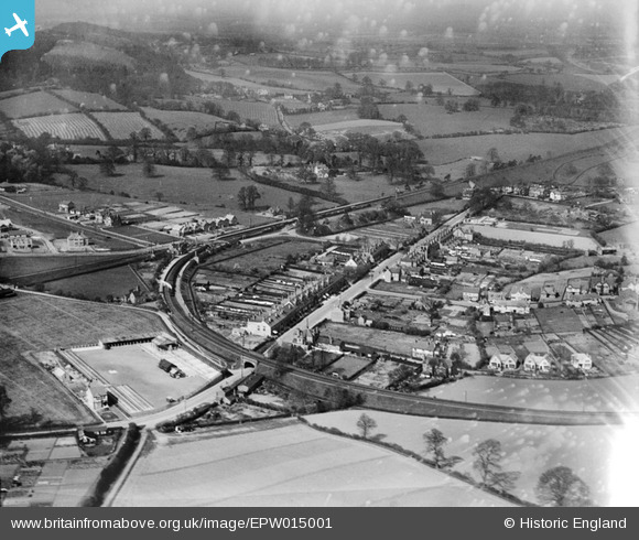
EPW015001 ENGLAND (1926). Hewell Road and environs, Barnt Green, 1926
© Copyright OpenStreetMap contributors and licensed by the OpenStreetMap Foundation. 2024. Cartography is licensed as CC BY-SA.
Nearby Images (4)
EPW015001

EPW015002

EPW015000

EPW013812

Details
| Title | [EPW015001] Hewell Road and environs, Barnt Green, 1926 |
| Reference | EPW015001 |
| Date | April-1926 |
| Link | |
| Place name | BARNT GREEN |
| Parish | BARNT GREEN |
| District | |
| Country | ENGLAND |
| Easting / Northing | 400689, 273680 |
| Longitude / Latitude | -1.9898811472175, 52.360793496645 |
| National Grid Reference | SP007737 |
Pins
 MIKEY Bee |
Saturday 16th of November 2019 11:10:16 PM | |
HM |
Sunday 23rd of December 2012 02:28:51 PM | |
MB |
Tuesday 25th of September 2012 02:21:16 PM | |
MB |
Tuesday 25th of September 2012 02:20:34 PM | |
MB |
Tuesday 25th of September 2012 02:19:12 PM | |
MB |
Tuesday 25th of September 2012 02:17:08 PM | |
MB |
Tuesday 25th of September 2012 02:16:41 PM | |
MB |
Tuesday 25th of September 2012 02:13:09 PM | |
MB |
Tuesday 25th of September 2012 02:12:38 PM | |
MB |
Tuesday 25th of September 2012 02:09:52 PM | |
BadgerMash |
Sunday 8th of July 2012 07:40:23 PM | |
ypres |
Wednesday 27th of June 2012 10:35:47 AM | |
ypres |
Wednesday 27th of June 2012 10:35:02 AM |
User Comment Contributions
My Grandparents would be horrified to see whats been built on the former "The Poplars Estate" Pre 1968, corner of Hewell & Bittel Rds = RIP = Happy days spent there in the Summer Holidays in the 60's! RIP |
HM |
Wednesday 19th of December 2012 12:38:52 PM |


