
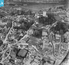
EPW014865 ENGLAND (1926). The Castle and environs, Conisbrough, 1926

© Copyright OpenStreetMap contributors and licensed by the OpenStreetMap Foundation. 2024. Cartography is licensed as CC BY-SA.
Nearby Images (9)
EPW014865

EPW014867

EPW012956

EPW015389

EPW014866

EAW005020

EAW005018

EAW005017

EAW005016

Details
| Title | [EPW014865] The Castle and environs, Conisbrough, 1926 |
| Reference | EPW014865 |
| Date | 5-April-1926 |
| Link | |
| Place name | CONISBROUGH |
| Parish | |
| District | |
| Country | ENGLAND |
| Easting / Northing | 451365, 398685 |
| Longitude / Latitude | -1.2258877339008, 53.482123876778 |
| National Grid Reference | SK514987 |
Pins
User Comment Contributions
 The Castle, Conisbrough |
 Robert - Cumbria |
Wednesday 27th of June 2012 09:03:19 PM |
Built in the 1180's by hamelin plantagenet. One of the finest examples of a norman keep. I remember this when the old steps were there and no roof on it as it is today. |
JulieW |
Wednesday 27th of June 2012 09:00:39 PM |
 The castle as it is today |
JulieW |
Wednesday 27th of June 2012 09:03:19 PM |


