
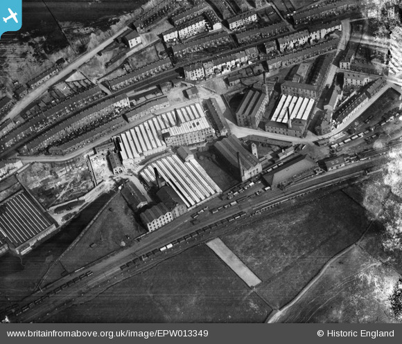
EPW013349 ENGLAND (1925). Cotton mills at Holden Vale, Haslingden, 1925
© Copyright OpenStreetMap contributors and licensed by the OpenStreetMap Foundation. 2024. Cartography is licensed as CC BY-SA.
Details
| Title | [EPW013349] Cotton mills at Holden Vale, Haslingden, 1925 |
| Reference | EPW013349 |
| Date | June-1925 |
| Link | |
| Place name | HASLINGDEN |
| Parish | |
| District | |
| Country | ENGLAND |
| Easting / Northing | 378537, 424010 |
| Longitude / Latitude | -2.3252219733218, 53.711843804477 |
| National Grid Reference | SD785240 |
Pins
 wadey |
Saturday 14th of July 2018 09:10:16 PM | |
wadey |
Saturday 14th of July 2018 09:09:07 PM | |
wadey |
Saturday 14th of July 2018 09:08:28 PM | |
wadey |
Saturday 14th of July 2018 09:07:14 PM | |
wadey |
Saturday 14th of July 2018 09:06:20 PM | |
wadey |
Saturday 14th of July 2018 09:05:27 PM | |
wadey |
Saturday 14th of July 2018 09:04:36 PM | |
wadey |
Saturday 14th of July 2018 09:03:38 PM |
User Comment Contributions
These Mills are actually on Blackburn Road Haslingden not at Holden Vale. The picture icon for the map is in the correct place. Most of the mills are long demolished but some remain. The station buildings and railway track running across the picture next to the fields were closed by Beeching in the 60's and the old track is now couvered by the Haslingden Bypass. |
drwell |
Thursday 2nd of May 2013 04:47:04 PM |
Hi drwell, Are you thinking of the mills like Commercial Mill on Blackburn Road, nearer to St James's Church? The mills in this photo include Victoria Mill, Britannia Mill and Albert Mill, slightly further north. Yours, Katy Britain from Above Cataloguing Team Leader |
Katy Whitaker |
Thursday 2nd of May 2013 04:47:04 PM |


