
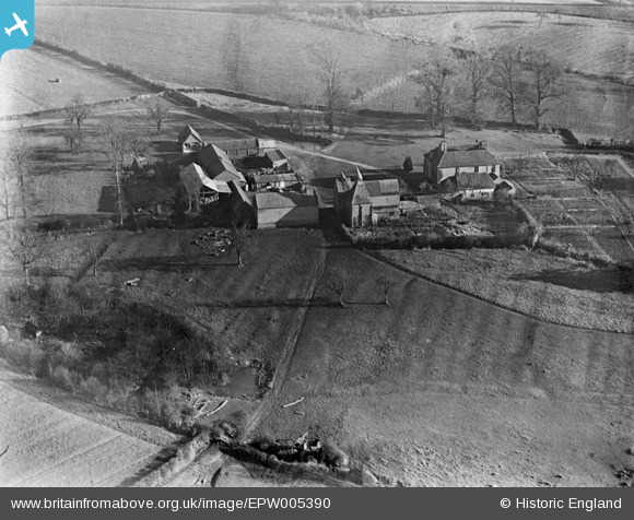
EPW005390 ENGLAND (1921). Brockbury Hall, Colwall, 1921
© Copyright OpenStreetMap contributors and licensed by the OpenStreetMap Foundation. 2024. Cartography is licensed as CC BY-SA.
Nearby Images (2)
EPW005390

EPW006127

Details
| Title | [EPW005390] Brockbury Hall, Colwall, 1921 |
| Reference | EPW005390 |
| Date | March-1921 |
| Link | |
| Place name | COLWALL |
| Parish | COLWALL |
| District | |
| Country | ENGLAND |
| Easting / Northing | 374541, 241840 |
| Longitude / Latitude | -2.3714977083038, 52.073922101691 |
| National Grid Reference | SO745418 |
Pins
 John New |
Sunday 8th of July 2012 10:26:58 PM | |
Chris Samuel |
Sunday 8th of July 2012 01:30:16 PM | |
Nemetostatio |
Tuesday 26th of June 2012 08:25:12 PM | |
Dennis Wilkinson |
Tuesday 12th of June 2012 12:59:59 PM | |
Dennis Wilkinson |
Tuesday 12th of June 2012 12:58:28 PM |
User Comment Contributions
I think it is Brockbury Hall - Most of the buildings fit as do most of the hedge rows although some of them are parch marks on Google earth rather than the hedges. Also the railway track running right along the top edge also fits. The image seems to be reversed |
Dave Brunt |
Tuesday 23rd of October 2012 12:40:42 PM |
Many thanks - not only a correct location, but also that the image needs to be flipped. We'll make the changes and the revised record with the correct location will appear here in due course, along with the image the right way around. Yours, Katy Britain from Above Cataloguing Team Leader |
Katy Whitaker |
Tuesday 23rd of October 2012 12:40:42 PM |
same farm as EPWO6127? |
dave43 |
Tuesday 7th of August 2012 03:24:04 PM |
Yep same farm but image reversed |
Dave Brunt |
Tuesday 7th of August 2012 03:24:04 PM |
Hops are also widely cultivated in Sussex, Worcestershire and Herefordshire. |
Tiny Tim |
Monday 16th of July 2012 04:22:42 PM |
I would guess that the field markings are medieval ridge and furrow as the fact that they don't follow the field boundaries at this time implies they predate them. |
Chris Samuel |
Sunday 8th of July 2012 01:27:49 PM |


