
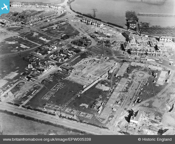
EPW005338 ENGLAND (1921). A new housing estate under construction at South Close, Dagenham, 1921
© Copyright OpenStreetMap contributors and licensed by the OpenStreetMap Foundation. 2024. Cartography is licensed as CC BY-SA.
Nearby Images (15)
EPW005338

EPW006556

EPW005340

EPW006558

EPW005343

EPW005339

EPW006559

EPW006557

EPW005341

EAW026138

EAW026158

EPW005342

EPW035589

EAW026156

EAW052719

Details
| Title | [EPW005338] A new housing estate under construction at South Close, Dagenham, 1921 |
| Reference | EPW005338 |
| Date | January-1921 |
| Link | |
| Place name | DAGENHAM |
| Parish | |
| District | |
| Country | ENGLAND |
| Easting / Northing | 549287, 183624 |
| Longitude / Latitude | 0.15250895583142, 51.531279972659 |
| National Grid Reference | TQ493836 |
Pins
Be the first to add a comment to this image!
User Comment Contributions
At the top of this picture is the junction of Whitebarn Lane, Marsh Green Road, Broad Street and Lower Broad Street. Whitebarn Lane exits the picture top right. Broad Street exits the picture at the top. Lower Broad Street is parallel to the top of the picture on the left. Marsh Green Road exits the picture below Lower Broad Street. At the bottom of the picture is New Road (the old A13) with South Close (cul de sac) joining New Road at the bottom right of the picture. To the right of South Close is the sight of Marsh Green Primary School which I attended between 1954 and 1960. Between Marsh Green Road and South Close is a children's park. |
 Ken Stanton |
Saturday 30th of June 2012 04:17:22 PM |


