
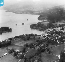
EPW004044 ENGLAND (1920). Bowness Bay and Rayrigg Wyke, Bowness on Windermere, from the south, 1920

© Copyright OpenStreetMap contributors and licensed by the OpenStreetMap Foundation. 2024. Cartography is licensed as CC BY-SA.
Nearby Images (5)
EPW004044

EPW026775

EPW026777

EAW023622

EPW004036

Details
| Title | [EPW004044] Bowness Bay and Rayrigg Wyke, Bowness on Windermere, from the south, 1920 |
| Reference | EPW004044 |
| Date | August-1920 |
| Link | |
| Place name | BOWNESS ON WINDERMERE |
| Parish | WINDERMERE |
| District | |
| Country | ENGLAND |
| Easting / Northing | 339991, 496400 |
| Longitude / Latitude | -2.9235509078094, 54.359440875918 |
| National Grid Reference | SD400964 |
Pins

User Comment Contributions
 Lake Windermere |
 Robert - Cumbria |
Wednesday 27th of June 2012 08:25:12 AM |
The site where the Sunderland Flying Boats were built During the second World War at White Cross Bay, approximately in the centre of this image on the far shore. Further Info: http://www.anotherspace.org.uk/flyingboatsonline/index.html |
Robert - Cumbria |
Tuesday 26th of June 2012 09:31:01 PM |


