
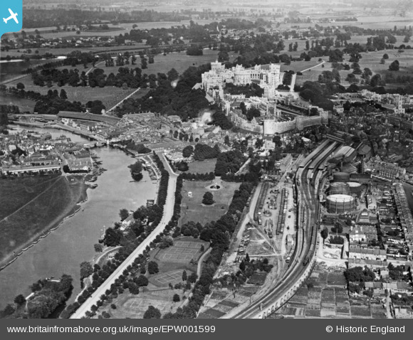
EPW001599 ENGLAND (1920). The Castle overlooking the Railway Station, Alexandra Gardens and the River Thames, Windsor, 1920. This image has been produced from a copy-negative.
© Copyright OpenStreetMap contributors and licensed by the OpenStreetMap Foundation. 2024. Cartography is licensed as CC BY-SA.
Nearby Images (16)
EPW001599

EAW042131

EPW047391

EPW022596

EPW001600

EPR000457

EPW012468

EPW053889

EAW004841

EAW053000

EAW003662

EAW003702

EAW042132

EAW004844

EAW003782

EPW022606

Details
| Title | [EPW001599] The Castle overlooking the Railway Station, Alexandra Gardens and the River Thames, Windsor, 1920. This image has been produced from a copy-negative. |
| Reference | EPW001599 |
| Date | June-1920 |
| Link | |
| Place name | WINDSOR |
| Parish | |
| District | |
| Country | ENGLAND |
| Easting / Northing | 496659, 177060 |
| Longitude / Latitude | -0.60780577274331, 51.483737706333 |
| National Grid Reference | SU967771 |
Pins
User Comment Contributions
Probably the first aerial view of this part of Windsor showing the bandstand in the Alexandra Gardens, the two ferrymen just upstream of the little island by the hire boats (the steamers would be Windsor Belle and Empress of India as The Windsor Castle was yet to be built). The trees in Thames Avenue, which was only constructed twenty or so years earlier, are clearly visible. Middle right of the picture is the 'town gas' works with its three chimneys which at that time would have been in full production. The allotment areas in the lower part of the picture are of social interest too but had to give way to an industrial estate later in the 20th century. |
 Thamesweb |
Wednesday 12th of November 2014 05:10:05 PM |


