
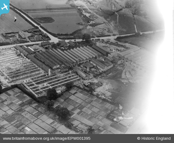
EPW001395 ENGLAND (1920). The Roneo Works, Romford, 1920
© Copyright OpenStreetMap contributors and licensed by the OpenStreetMap Foundation. 2024. Cartography is licensed as CC BY-SA.
Nearby Images (11)
EPW001395

EAW013355

EAW013353

EAW013352

EAW013356

EAW013350

EAW013357

EAW013348

EAW013358

EAW013354

EAW013351

Details
| Title | [EPW001395] The Roneo Works, Romford, 1920 |
| Reference | EPW001395 |
| Date | 7-June-1920 |
| Link | |
| Place name | ROMFORD |
| Parish | |
| District | |
| Country | ENGLAND |
| Easting / Northing | 551768, 187534 |
| Longitude / Latitude | 0.18994062958501, 51.565753175562 |
| National Grid Reference | TQ518875 |
Pins
 Davel |
Saturday 31st of May 2014 04:27:14 PM | |
Davel |
Saturday 31st of May 2014 04:25:33 PM | |
James McEwan |
Saturday 30th of November 2013 03:08:41 AM | |
James McEwan |
Saturday 30th of November 2013 03:07:38 AM | |
 Class31 |
Tuesday 30th of October 2012 09:09:28 AM | |
Class31 |
Tuesday 30th of October 2012 09:08:39 AM | |
Class31 |
Tuesday 30th of October 2012 09:08:12 AM | |
BigglesH |
Monday 16th of July 2012 04:31:48 AM | |
BigglesH |
Monday 16th of July 2012 04:26:14 AM |
User Comment Contributions
Some people still call this Roneo Corner. How times change - who now remembers `Duplicators` with wax `stencil` sheets you `cut` with a manual typewriter - after removing the fabric `ribbon`. No spell checks then - if the Pitman `shorthand` secretary made one mistake it was `start all over again`. No `laser` printers and no spell checkers - just how did they do it? |
Roy |
Tuesday 18th of November 2014 05:00:06 PM |
You are correct. Also, the brewery was built by the river as a source of water. |
 powerpop |
Tuesday 18th of November 2014 05:00:06 PM |


