
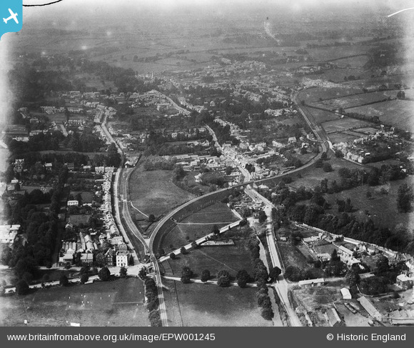
EPW001245 ENGLAND (1920). View of Hemel Hempstead, Hemel Hempstead,1920
© Copyright OpenStreetMap contributors and licensed by the OpenStreetMap Foundation. 2024. Cartography is licensed as CC BY-SA.
Nearby Images (3)
EPW001245

EPW001242

EPW022455

Details
| Title | [EPW001245] View of Hemel Hempstead, Hemel Hempstead,1920 |
| Reference | EPW001245 |
| Date | May-1920 |
| Link | |
| Place name | HEMEL HEMPSTEAD |
| Parish | |
| District | |
| Country | ENGLAND |
| Easting / Northing | 505494, 206642 |
| Longitude / Latitude | -0.47169298527254, 51.748075361233 |
| National Grid Reference | TL055066 |
Pins
 DVT |
Saturday 14th of November 2020 02:16:53 PM | |
DVT |
Wednesday 11th of November 2020 06:53:00 PM | |
OldBill |
Thursday 2nd of January 2020 08:23:23 PM | |
okthen |
Friday 18th of October 2013 02:42:57 PM | |
okthen |
Friday 18th of October 2013 02:42:06 PM | |
okthen |
Friday 18th of October 2013 02:41:09 PM | |
JanetH |
Sunday 24th of February 2013 11:19:46 PM | |
JanetH |
Sunday 24th of February 2013 11:18:40 PM | |
JanetH |
Sunday 24th of February 2013 11:18:09 PM |
User Comment Contributions
 Hemel Hempstead Station just visible immediately below 'Y' junction at bottom left of photo. (Not to be confused with the station of the same name on the W.C.M.L.) |
Puffpuffbuff |
Tuesday 26th of June 2012 08:12:18 AM |


