
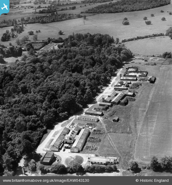
EAW043130 ENGLAND (1952). RAF Hunsdon Dispersed Site 1, Hunsdon, 1952.
© Copyright OpenStreetMap contributors and licensed by the OpenStreetMap Foundation. 2024. Cartography is licensed as CC BY-SA.
Nearby Images (10)
EAW043130

EAW043131

EAW043129

EAW043132

EAW043127

EAW043128

EAW043125

EAW043134

EAW043133

EAW043126

Details
| Title | [EAW043130] RAF Hunsdon Dispersed Site 1, Hunsdon, 1952. |
| Reference | EAW043130 |
| Date | 21-May-1952 |
| Link | |
| Place name | HUNSDON |
| Parish | HUNSDON |
| District | |
| Country | ENGLAND |
| Easting / Northing | 541100, 213403 |
| Longitude / Latitude | 0.046574263494376, 51.800995951468 |
| National Grid Reference | TL411134 |
Pins
 Matt Aldred edob.mattaldred.com |
Sunday 21st of June 2020 12:24:06 PM | |
Matt Aldred edob.mattaldred.com |
Sunday 21st of June 2020 12:23:58 PM | |
 ewnmcg |
Monday 3rd of November 2014 07:50:24 PM | |
ewnmcg |
Monday 3rd of November 2014 07:49:52 PM |
User Comment Contributions
 The dispersal site No. 1 as it appears in a map dated about 1975. |
ewnmcg |
Monday 3rd of November 2014 07:49:28 PM |
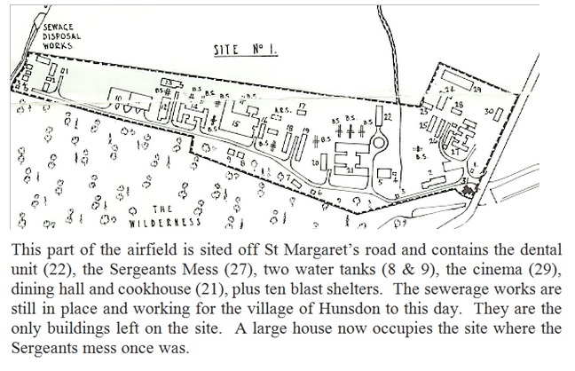 The attached is a plan of dispersal site No. 1 |
ewnmcg |
Monday 3rd of November 2014 07:45:45 PM |
This is dispersal site No. 1 for RAF Hunsdon, Herts. This site lies off St Margaret’s road and contains the dental unit (22), the Sergeants Mess (27), two water tanks (8 & 9), the cinema (29), dining hall and cookhouse (21), plus ten blast shelters. The sewerage works are still in place and working for the village of Hunsdon to this day. They are the only buildings left on the site. A large house now occupies the site where the Sergeants mess once was. The Grid Reference is TL 413 134. I have attached more information with Image Ref. EAW043134. |
ewnmcg |
Monday 3rd of November 2014 07:45:12 PM |


