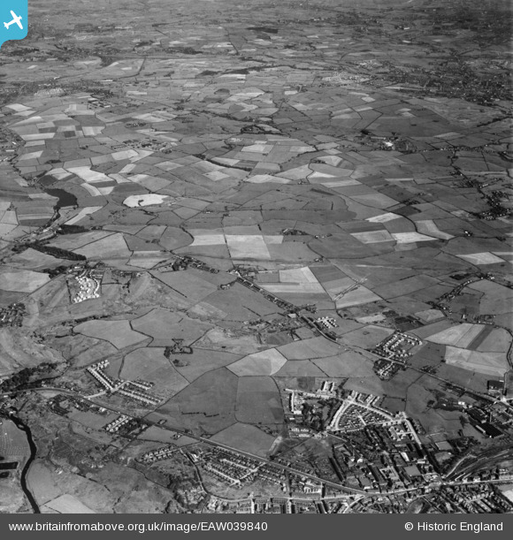
EAW039840 ENGLAND (1951). New housing by The Elms and Sunny Bank and the surrounding fields, Whitefield, from the west, 1951
© Copyright OpenStreetMap contributors and licensed by the OpenStreetMap Foundation. 2024. Cartography is licensed as CC BY-SA.
Details
| Title | [EAW039840] New housing by The Elms and Sunny Bank and the surrounding fields, Whitefield, from the west, 1951 |
| Reference | EAW039840 |
| Date | 15-September-1951 |
| Link | |
| Place name | WHITEFIELD |
| Parish | |
| District | |
| Country | ENGLAND |
| Easting / Northing | 380965, 406801 |
| Longitude / Latitude | -2.2873786209985, 53.557243813669 |
| National Grid Reference | SD810068 |
Pins
 Richard Clayton |
Wednesday 14th of October 2020 09:11:07 PM | |
 Richard Clayton |
Wednesday 14th of October 2020 09:10:24 PM | |
 Richard Clayton |
Wednesday 14th of October 2020 09:09:19 PM | |
 Richard Clayton |
Wednesday 14th of October 2020 09:08:35 PM | |
 Richard Clayton |
Wednesday 14th of October 2020 09:05:38 PM | |
 Richard Clayton |
Wednesday 14th of October 2020 09:04:16 PM | |
 Richard Clayton |
Wednesday 14th of October 2020 09:03:44 PM | |
 Richard Clayton |
Wednesday 14th of October 2020 09:01:59 PM | |
 Richard Clayton |
Wednesday 14th of October 2020 09:00:49 PM | |
 Richard Clayton |
Wednesday 14th of October 2020 08:59:38 PM | |
 Richard Clayton |
Wednesday 14th of October 2020 08:58:48 PM | |
 jsolisv |
Tuesday 27th of May 2014 09:21:35 PM | |
 boltie |
Wednesday 7th of May 2014 12:32:35 PM | |
 boltie |
Wednesday 7th of May 2014 12:31:12 PM |


![[EAW039840] New housing by The Elms and Sunny Bank and the surrounding fields, Whitefield, from the west, 1951](http://britainfromabove.org.uk/sites/all/libraries/aerofilms-images/public/100x100/EAW/039/EAW039840.jpg)
![[EAW039839] New housing by The Elms and Sunny Bank and the surrounding fields, Whitefield, from the north-west, 1951](http://britainfromabove.org.uk/sites/all/libraries/aerofilms-images/public/100x100/EAW/039/EAW039839.jpg)
![[EAW039830] New housing by The Elms and surrounding fields, Whitefield, from the north-west, 1951](http://britainfromabove.org.uk/sites/all/libraries/aerofilms-images/public/100x100/EAW/039/EAW039830.jpg)


