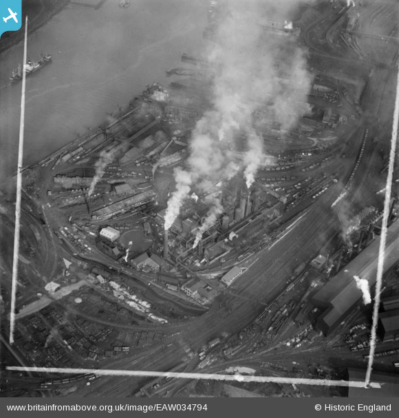
EAW034794 ENGLAND (1951). The Normanby Iron Works, Middlesbrough, 1951. This image was marked by Aerofilms Ltd for photo editing.
© Copyright OpenStreetMap contributors and licensed by the OpenStreetMap Foundation. 2024. Cartography is licensed as CC BY-SA.
Nearby Images (19)
Details
| Title | [EAW034794] The Normanby Iron Works, Middlesbrough, 1951. This image was marked by Aerofilms Ltd for photo editing. |
| Reference | EAW034794 |
| Date | 28-February-1951 |
| Link | |
| Place name | MIDDLESBROUGH |
| Parish | |
| District | |
| Country | ENGLAND |
| Easting / Northing | 451821, 520734 |
| Longitude / Latitude | -1.1981844971904, 54.579032014926 |
| National Grid Reference | NZ518207 |
Pins
Be the first to add a comment to this image!


![[EAW034794] The Normanby Iron Works, Middlesbrough, 1951. This image was marked by Aerofilms Ltd for photo editing.](http://britainfromabove.org.uk/sites/all/libraries/aerofilms-images/public/100x100/EAW/034/EAW034794.jpg)
![[EAW034796] The Normanby Iron Works, Middlesbrough, 1951. This image was marked by Aerofilms Ltd for photo editing.](http://britainfromabove.org.uk/sites/all/libraries/aerofilms-images/public/100x100/EAW/034/EAW034796.jpg)
![[EAW034790] The Normanby Iron Works, Middlesbrough, 1951. This image was marked by Aerofilms Ltd for photo editing.](http://britainfromabove.org.uk/sites/all/libraries/aerofilms-images/public/100x100/EAW/034/EAW034790.jpg)
![[EAW034781] The Normanby Iron Works, Middlesbrough, 1951](http://britainfromabove.org.uk/sites/all/libraries/aerofilms-images/public/100x100/EAW/034/EAW034781.jpg)
![[EAW034784] The Normanby Iron Works, Middlesbrough, 1951. This image was marked by Aerofilms Ltd for photo editing.](http://britainfromabove.org.uk/sites/all/libraries/aerofilms-images/public/100x100/EAW/034/EAW034784.jpg)
![[EAW034783] The Normanby Iron Works, Middlesbrough, 1951. This image was marked by Aerofilms Ltd for photo editing.](http://britainfromabove.org.uk/sites/all/libraries/aerofilms-images/public/100x100/EAW/034/EAW034783.jpg)
![[EAW034791] The Normanby Iron Works, Middlesbrough, 1951. This image was marked by Aerofilms Ltd for photo editing.](http://britainfromabove.org.uk/sites/all/libraries/aerofilms-images/public/100x100/EAW/034/EAW034791.jpg)
![[EAW034786] The Normanby Iron Works, Middlesbrough, 1951. This image was marked by Aerofilms Ltd for photo editing.](http://britainfromabove.org.uk/sites/all/libraries/aerofilms-images/public/100x100/EAW/034/EAW034786.jpg)
![[EAW034785] The Normanby Iron Works, Middlesbrough, 1951. This image was marked by Aerofilms Ltd for photo editing.](http://britainfromabove.org.uk/sites/all/libraries/aerofilms-images/public/100x100/EAW/034/EAW034785.jpg)
![[EAW034787] The Normanby Iron Works, Middlesbrough, 1951](http://britainfromabove.org.uk/sites/all/libraries/aerofilms-images/public/100x100/EAW/034/EAW034787.jpg)
![[EAW034788] The Normanby Iron Works, Middlesbrough, 1951. This image was marked by Aerofilms Ltd for photo editing.](http://britainfromabove.org.uk/sites/all/libraries/aerofilms-images/public/100x100/EAW/034/EAW034788.jpg)
![[EAW034789] The Normanby Iron Works, Middlesbrough, 1951. This image was marked by Aerofilms Ltd for photo editing.](http://britainfromabove.org.uk/sites/all/libraries/aerofilms-images/public/100x100/EAW/034/EAW034789.jpg)
![[EAW034795] The Normanby Iron Works, Middlesbrough, 1951. This image was marked by Aerofilms Ltd for photo editing.](http://britainfromabove.org.uk/sites/all/libraries/aerofilms-images/public/100x100/EAW/034/EAW034795.jpg)
![[EAW034793] The Normanby Iron Works, Middlesbrough, 1951. This image was marked by Aerofilms Ltd for photo editing.](http://britainfromabove.org.uk/sites/all/libraries/aerofilms-images/public/100x100/EAW/034/EAW034793.jpg)
![[EAW034782] The Normanby Iron Works, Middlesbrough, 1951](http://britainfromabove.org.uk/sites/all/libraries/aerofilms-images/public/100x100/EAW/034/EAW034782.jpg)
![[EAW034792] The Normanby Iron Works, Middlesbrough, 1951](http://britainfromabove.org.uk/sites/all/libraries/aerofilms-images/public/100x100/EAW/034/EAW034792.jpg)
![[EAW007967] The town and the River Tees, Middlesbrough, from the north-east, 1947](http://britainfromabove.org.uk/sites/all/libraries/aerofilms-images/public/100x100/EAW/007/EAW007967.jpg)
![[EPW055925] The South Durham Iron and Steel Works, South Bank, 1937](http://britainfromabove.org.uk/sites/all/libraries/aerofilms-images/public/100x100/EPW/055/EPW055925.jpg)
![[EPW055916] The South Durham Iron and Steel Works, South Bank, 1937](http://britainfromabove.org.uk/sites/all/libraries/aerofilms-images/public/100x100/EPW/055/EPW055916.jpg)


