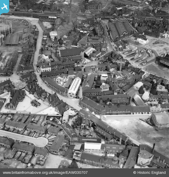
EAW030707 ENGLAND (1950). Cooke Street and the John Beswick Ltd Earthenware Factory off Gold Street, Longton, 1950
© Copyright OpenStreetMap contributors and licensed by the OpenStreetMap Foundation. 2024. Cartography is licensed as CC BY-SA.
Nearby Images (21)
Details
| Title | [EAW030707] Cooke Street and the John Beswick Ltd Earthenware Factory off Gold Street, Longton, 1950 |
| Reference | EAW030707 |
| Date | June-1950 |
| Link | |
| Place name | LONGTON |
| Parish | |
| District | |
| Country | ENGLAND |
| Easting / Northing | 390798, 343341 |
| Longitude / Latitude | -2.1370895259255, 52.987016939963 |
| National Grid Reference | SJ908433 |
Pins
Be the first to add a comment to this image!


![[EAW030707] Cooke Street and the John Beswick Ltd Earthenware Factory off Gold Street, Longton, 1950](http://britainfromabove.org.uk/sites/all/libraries/aerofilms-images/public/100x100/EAW/030/EAW030707.jpg)
![[EAW030701] Cooke Street and the John Beswick Ltd Earthenware Factory off Gold Street, Longton, 1950. This image was marked by Aerofilms Ltd for photo editing.](http://britainfromabove.org.uk/sites/all/libraries/aerofilms-images/public/100x100/EAW/030/EAW030701.jpg)
![[EAW030704] John Beswick Ltd Earthenware Factory off Gold Street and the Bus Station, Longton, 1950](http://britainfromabove.org.uk/sites/all/libraries/aerofilms-images/public/100x100/EAW/030/EAW030704.jpg)
![[EAW030703] John Beswick Ltd Earthenware Factory off Gold Street, Longton, 1950](http://britainfromabove.org.uk/sites/all/libraries/aerofilms-images/public/100x100/EAW/030/EAW030703.jpg)
![[EAW030705] Cooke Street and the John Beswick Ltd Earthenware Factory off Gold Street, Longton, 1950. This image was marked by Aerofilms Ltd for photo editing.](http://britainfromabove.org.uk/sites/all/libraries/aerofilms-images/public/100x100/EAW/030/EAW030705.jpg)
![[EAW030699] John Beswick Ltd Earthenware Factory off Gold Street, Longton, 1950. This image was marked by Aerofilms Ltd for photo editing.](http://britainfromabove.org.uk/sites/all/libraries/aerofilms-images/public/100x100/EAW/030/EAW030699.jpg)
![[EAW030706] John Beswick Ltd Earthenware Factory off Gold Street and St Gregory's Roman Catholic Church, Longton, 1950](http://britainfromabove.org.uk/sites/all/libraries/aerofilms-images/public/100x100/EAW/030/EAW030706.jpg)
![[EAW030697] John Beswick Ltd Earthenware Factory off Gold Street and the Bus Station, Longton, 1950](http://britainfromabove.org.uk/sites/all/libraries/aerofilms-images/public/100x100/EAW/030/EAW030697.jpg)
![[EAW021609] The Edensor and Cobden China Works and environs, Longton, 1949. This image has been produced from a print marked by Aerofilms Ltd for photo editing.](http://britainfromabove.org.uk/sites/all/libraries/aerofilms-images/public/100x100/EAW/021/EAW021609.jpg)
![[EAW030698] John Beswick Ltd Earthenware Factory off Gold Street and St Gregory's Roman Catholic Church, Longton, 1950. This image was marked by Aerofilms Ltd for photo editing.](http://britainfromabove.org.uk/sites/all/libraries/aerofilms-images/public/100x100/EAW/030/EAW030698.jpg)
![[EAW030700] John Beswick Ltd Earthenware Factory off Gold Street and St Gregory's Roman Catholic Church, Longton, 1950](http://britainfromabove.org.uk/sites/all/libraries/aerofilms-images/public/100x100/EAW/030/EAW030700.jpg)
![[EAW030708] John Beswick Ltd Earthenware Factory off Gold Street, Longton, 1950. This image was marked by Aerofilms Ltd for photo editing.](http://britainfromabove.org.uk/sites/all/libraries/aerofilms-images/public/100x100/EAW/030/EAW030708.jpg)
![[EAW030702] John Beswick Ltd Earthenware Factory off Gold Street, Longton, 1950](http://britainfromabove.org.uk/sites/all/libraries/aerofilms-images/public/100x100/EAW/030/EAW030702.jpg)
![[EAW021616] The Edensor and Cobden China Works and environs, Longton, 1949. This image has been produced from a print marked by Aerofilms Ltd for photo editing.](http://britainfromabove.org.uk/sites/all/libraries/aerofilms-images/public/100x100/EAW/021/EAW021616.jpg)
![[EAW021612] The Edensor and Cobden China Works and environs, Longton, 1949. This image has been produced from a print marked by Aerofilms Ltd for photo editing.](http://britainfromabove.org.uk/sites/all/libraries/aerofilms-images/public/100x100/EAW/021/EAW021612.jpg)
![[EAW021614] The Edensor and Cobden China Works and environs, Longton, 1949. This image has been produced from a print marked by Aerofilms Ltd for photo editing.](http://britainfromabove.org.uk/sites/all/libraries/aerofilms-images/public/100x100/EAW/021/EAW021614.jpg)
![[EAW021613] The Edensor and Cobden China Works and environs, Longton, 1949. This image has been produced from a print marked by Aerofilms Ltd for photo editing.](http://britainfromabove.org.uk/sites/all/libraries/aerofilms-images/public/100x100/EAW/021/EAW021613.jpg)
![[EAW013144] The potteries and the town, Longton, from the north-west, 1948](http://britainfromabove.org.uk/sites/all/libraries/aerofilms-images/public/100x100/EAW/013/EAW013144.jpg)
![[EAW021611] The Edensor and Cobden China Works and environs, Longton, 1949. This image has been produced from a print marked by Aerofilms Ltd for photo editing.](http://britainfromabove.org.uk/sites/all/libraries/aerofilms-images/public/100x100/EAW/021/EAW021611.jpg)
![[EAW021610] The Edensor and Cobden China Works and environs, Longton, 1949. This image has been produced from a print marked by Aerofilms Ltd for photo editing.](http://britainfromabove.org.uk/sites/all/libraries/aerofilms-images/public/100x100/EAW/021/EAW021610.jpg)
![[EPR000430] Edensor Road and smoke over the surrounding potteries, Longton, 1934](http://britainfromabove.org.uk/sites/all/libraries/aerofilms-images/public/100x100/EPR/000/EPR000430.jpg)


