
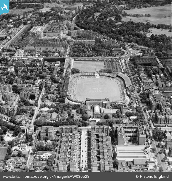
EAW030528 ENGLAND (1950). St John's Wood, a test match (England vs West Indies) underway at Lord's Cricket Ground, 1950
© Copyright OpenStreetMap contributors and licensed by the OpenStreetMap Foundation. 2024. Cartography is licensed as CC BY-SA.
Nearby Images (34)
EAW030528
 underway at Lord's Cricket Ground, 1950")
EPW031880

EAW006466

EPW006681

EPW006155

EAW006465

EAW015848

EPW006684

EPW006688

EAW015849

EPW006683

EPW039574

EAW030526
 underway at Lord's Cricket Ground, 1950")
EPW015772

EAW006464

EPW006682

EPW006686

EAW024223

EAW024224

EPW006687

EPW021969

EAW024225

EAW030527
 underway at Lord's Cricket Ground, 1950")
EPW021968

EPW006685

EAW018353

EAW044241

EPW009093

EAW044240

EPW005641

EPW009007

EPW009008

EPW009006

EAW018354

Details
| Title | [EAW030528] St John's Wood, a test match (England vs West Indies) underway at Lord's Cricket Ground, 1950 |
| Reference | EAW030528 |
| Date | 26-June-1950 |
| Link | |
| Place name | ST JOHN'S WOOD |
| Parish | |
| District | |
| Country | ENGLAND |
| Easting / Northing | 526850, 182781 |
| Longitude / Latitude | -0.17111176650157, 51.529191305459 |
| National Grid Reference | TQ269828 |
Pins
 v6tek |
Saturday 29th of May 2021 01:19:00 AM |


