
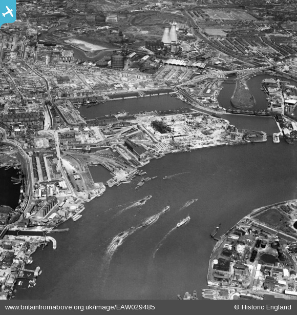
EAW029485 ENGLAND (1950). Brunswick Wharf Power Station under construction and the surrounding docks and river, Blackwall, 1950
© Copyright OpenStreetMap contributors and licensed by the OpenStreetMap Foundation. 2024. Cartography is licensed as CC BY-SA.
Nearby Images (46)
EAW029485

EAW012156
, Blackwall, 1947. This image was marked by Aerofilms Ltd for photo editing.")
EAW013362

EAW012155
, Blackwall, 1947. This image was marked by Aerofilms Ltd for photo editing.")
EAW004326

EAW013626

EAW013624

EAW053005
 Power Station, East India Docks and environs, Blackwall, 1953")
EAW008750

EAW013627

EAW024919

EAW013629

EAW013633

EAW004330

EAW012157
, Blackwall, 1947. This image was marked by Aerofilms Ltd for photo editing.")
EAW024918

EAW013364

EAW004331

EAW013628

EAW024922

EAW004327

EAW013631

EAW024915

EAW024914
 Dock, Blackwall, 1949")
EPW009112

EAW024916

EAW024920

EAW013630

EAW008751

EAW024921
 Dock, Blackwall, 1949. This image was marked by Aerofilms Ltd for photo editing.")
EAW004328

EAW024917

EAW013366

EAW008753

EAW036440
 on the River Thames, Blackwall Reach, 1951. This image has been produced from a print.")
EAW004325

EPW011938

EAW004332

EAW013359

EAW013365

EAW004329

EAW013632

EAW008749

EAW013625

EAW013634

EAW008752

Details
| Title | [EAW029485] Brunswick Wharf Power Station under construction and the surrounding docks and river, Blackwall, 1950 |
| Reference | EAW029485 |
| Date | 11-May-1950 |
| Link | |
| Place name | BLACKWALL |
| Parish | |
| District | |
| Country | ENGLAND |
| Easting / Northing | 538705, 180632 |
| Longitude / Latitude | -0.00114274743549, 51.507090202738 |
| National Grid Reference | TQ387806 |
Pins
 Grollo |
Monday 1st of September 2014 10:29:51 PM | |
Grollo |
Saturday 30th of August 2014 12:58:26 PM | |
Grollo |
Saturday 30th of August 2014 12:55:04 PM | |
 |
Grollo |
Wednesday 26th of March 2014 08:59:07 AM |
Smudger |
Tuesday 25th of March 2014 12:00:16 PM | |
Grollo |
Tuesday 18th of March 2014 06:47:08 PM | |
Grollo |
Tuesday 18th of March 2014 06:44:45 PM | |
Grollo |
Tuesday 18th of March 2014 06:29:03 PM | |
Grollo |
Tuesday 18th of March 2014 06:26:36 PM | |
Grollo |
Tuesday 18th of March 2014 06:21:53 PM | |
Grollo |
Tuesday 18th of March 2014 06:20:24 PM | |
Grollo |
Tuesday 18th of March 2014 06:19:40 PM |


