
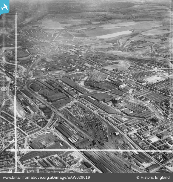
EAW026019 ENGLAND (1949). The English Steel Corporation Ltd River Don Works, Brightside Sidings and environs, Carbrook, 1949. This image was marked by Aerofilms Ltd for photo editing.
© Copyright OpenStreetMap contributors and licensed by the OpenStreetMap Foundation. 2024. Cartography is licensed as CC BY-SA.
Nearby Images (28)
EAW026019

EAW018782

EAW026010

EAW022027

EAW018781

EAW020060

EAW020054

EAW018783

EAW020061

EAW018784

EAW022025

EAW018786

EAW026021

EAW018785

EPW007785

EPW007788

EAW022024

EAW026012

EPW007789

EAW026016

EAW022028

EAW026009

EAW026018

EAW026015

EAW026014

EPW007786

EAW026013

EAW020057

Details
| Title | [EAW026019] The English Steel Corporation Ltd River Don Works, Brightside Sidings and environs, Carbrook, 1949. This image was marked by Aerofilms Ltd for photo editing. |
| Reference | EAW026019 |
| Date | 14-August-1949 |
| Link | |
| Place name | CARBROOK |
| Parish | |
| District | |
| Country | ENGLAND |
| Easting / Northing | 438415, 389965 |
| Longitude / Latitude | -1.4221067072154, 53.404843733358 |
| National Grid Reference | SK384900 |
Pins
 jonron |
Friday 1st of March 2024 01:04:56 PM | |
fourty one c |
Monday 29th of October 2018 02:46:44 PM | |
fourty one c |
Monday 29th of October 2018 02:45:19 PM | |
 Class31 |
Monday 23rd of November 2015 09:02:06 AM |


