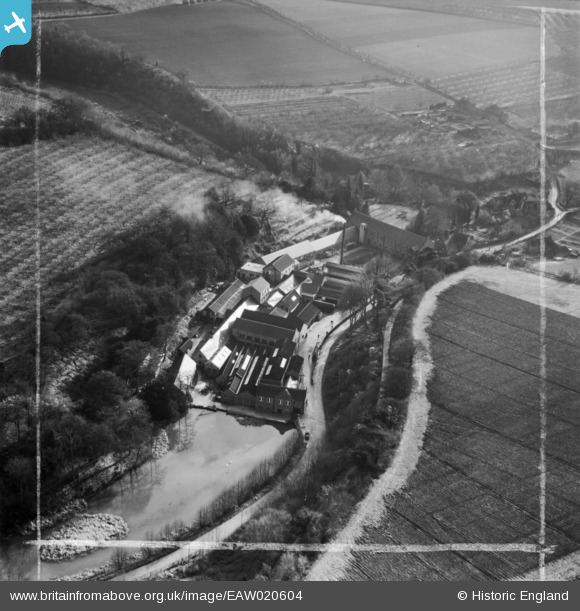
EAW020604 ENGLAND (1948). Basted Paper Mills, Basted, 1948. This image was marked by Aerofilms Ltd for photo editing.
© Copyright OpenStreetMap contributors and licensed by the OpenStreetMap Foundation. 2024. Cartography is licensed as CC BY-SA.
Nearby Images (21)
Details
| Title | [EAW020604] Basted Paper Mills, Basted, 1948. This image was marked by Aerofilms Ltd for photo editing. |
| Reference | EAW020604 |
| Date | 8-December-1948 |
| Link | |
| Place name | BASTED |
| Parish | PLATT |
| District | |
| Country | ENGLAND |
| Easting / Northing | 560738, 155977 |
| Longitude / Latitude | 0.3049475366578, 51.279718447148 |
| National Grid Reference | TQ607560 |
Pins
Be the first to add a comment to this image!


![[EAW020604] Basted Paper Mills, Basted, 1948. This image was marked by Aerofilms Ltd for photo editing.](http://britainfromabove.org.uk/sites/all/libraries/aerofilms-images/public/100x100/EAW/020/EAW020604.jpg)
![[EAW014296] Basted Paper Mills, Basted, 1948](http://britainfromabove.org.uk/sites/all/libraries/aerofilms-images/public/100x100/EAW/014/EAW014296.jpg)
![[EAW020612] Basted Paper Mills and the surrounding countryside, Basted, 1948](http://britainfromabove.org.uk/sites/all/libraries/aerofilms-images/public/100x100/EAW/020/EAW020612.jpg)
![[EAW020605] Basted Paper Mills, Basted, 1948. This image was marked by Aerofilms Ltd for photo editing.](http://britainfromabove.org.uk/sites/all/libraries/aerofilms-images/public/100x100/EAW/020/EAW020605.jpg)
![[EAW014298] Basted Paper Mills, Basted, 1948](http://britainfromabove.org.uk/sites/all/libraries/aerofilms-images/public/100x100/EAW/014/EAW014298.jpg)
![[EAW014302] Basted Paper Mills, Basted, 1948. This image has been produced from a print.](http://britainfromabove.org.uk/sites/all/libraries/aerofilms-images/public/100x100/EAW/014/EAW014302.jpg)
![[EAW014300] Basted Paper Mills, Basted, 1948](http://britainfromabove.org.uk/sites/all/libraries/aerofilms-images/public/100x100/EAW/014/EAW014300.jpg)
![[EAW020606] Basted Paper Mills, Basted, 1948. This image was marked by Aerofilms Ltd for photo editing.](http://britainfromabove.org.uk/sites/all/libraries/aerofilms-images/public/100x100/EAW/020/EAW020606.jpg)
![[EAW020609] Basted Paper Mills, Basted, 1948. This image was marked by Aerofilms Ltd for photo editing.](http://britainfromabove.org.uk/sites/all/libraries/aerofilms-images/public/100x100/EAW/020/EAW020609.jpg)
![[EAW020603] Basted Paper Mills, Basted, 1948. This image was marked by Aerofilms Ltd for photo editing.](http://britainfromabove.org.uk/sites/all/libraries/aerofilms-images/public/100x100/EAW/020/EAW020603.jpg)
![[EAW020613] Basted Paper Mills, Basted, 1948. This image was marked by Aerofilms Ltd for photo editing.](http://britainfromabove.org.uk/sites/all/libraries/aerofilms-images/public/100x100/EAW/020/EAW020613.jpg)
![[EAW014297] Basted Paper Mills, Basted, 1948](http://britainfromabove.org.uk/sites/all/libraries/aerofilms-images/public/100x100/EAW/014/EAW014297.jpg)
![[EAW014303] Basted Paper Mills, Basted, 1948. This image has been produced from a print marked by Aerofilms Ltd for photo editing.](http://britainfromabove.org.uk/sites/all/libraries/aerofilms-images/public/100x100/EAW/014/EAW014303.jpg)
![[EAW020602] Basted Paper Mills, Basted, 1948. This image was marked by Aerofilms Ltd for photo editing.](http://britainfromabove.org.uk/sites/all/libraries/aerofilms-images/public/100x100/EAW/020/EAW020602.jpg)
![[EAW014301] Basted Paper Mills, Basted, 1948. This image has been produced from a print.](http://britainfromabove.org.uk/sites/all/libraries/aerofilms-images/public/100x100/EAW/014/EAW014301.jpg)
![[EAW020601] Basted Paper Mills, Basted, 1948](http://britainfromabove.org.uk/sites/all/libraries/aerofilms-images/public/100x100/EAW/020/EAW020601.jpg)
![[EAW014299] Basted Paper Mills, Basted, 1948](http://britainfromabove.org.uk/sites/all/libraries/aerofilms-images/public/100x100/EAW/014/EAW014299.jpg)
![[EAW020608] Basted Paper Mills, Basted, 1948. This image was marked by Aerofilms Ltd for photo editing.](http://britainfromabove.org.uk/sites/all/libraries/aerofilms-images/public/100x100/EAW/020/EAW020608.jpg)
![[EAW020610] Basted Paper Mills and the surrounding countryside, Basted, 1948. This image was marked by Aerofilms Ltd for photo editing.](http://britainfromabove.org.uk/sites/all/libraries/aerofilms-images/public/100x100/EAW/020/EAW020610.jpg)
![[EAW020607] Basted Paper Mills, Basted, 1948. This image was marked by Aerofilms Ltd for photo editing.](http://britainfromabove.org.uk/sites/all/libraries/aerofilms-images/public/100x100/EAW/020/EAW020607.jpg)
![[EAW020611] Basted Paper Mills and the surrounding countryside, Basted, from the north-west, 1948. This image was marked by Aerofilms Ltd for photo editing.](http://britainfromabove.org.uk/sites/all/libraries/aerofilms-images/public/100x100/EAW/020/EAW020611.jpg)


