
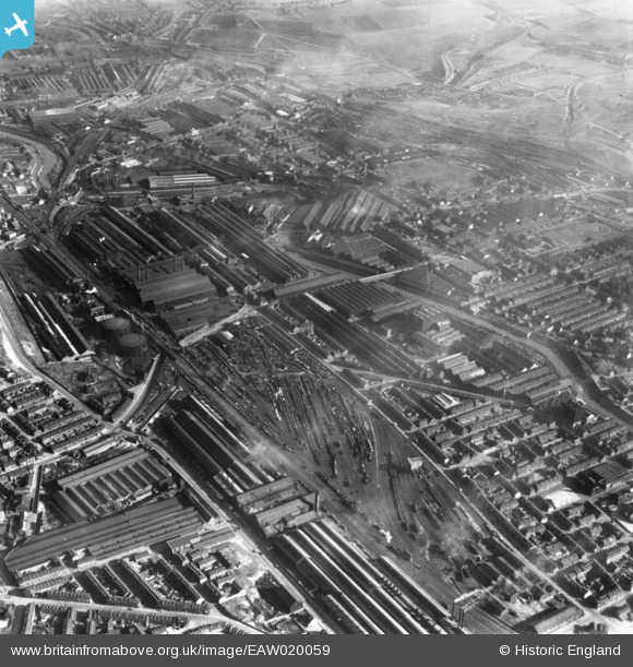
EAW020059 ENGLAND (1948). The English Steel Corporation River Don Steel Works and environs, Brightside, 1948. This image has been produced from a print.
© Copyright OpenStreetMap contributors and licensed by the OpenStreetMap Foundation. 2024. Cartography is licensed as CC BY-SA.
Nearby Images (18)
EAW020059

EAW020057

EAW020058

EAW022028

EPW007788

EAW018780

EPW007159

EAW026021

EAW026012

EAW026011

EAW018786

EAW026022

EPW007789

EAW018783

EAW026010

EAW018781

EAW022027

EAW022025

Details
| Title | [EAW020059] The English Steel Corporation River Don Steel Works and environs, Brightside, 1948. This image has been produced from a print. |
| Reference | EAW020059 |
| Date | 19-October-1948 |
| Link | |
| Place name | BRIGHTSIDE |
| Parish | |
| District | |
| Country | ENGLAND |
| Easting / Northing | 438130, 389856 |
| Longitude / Latitude | -1.4264070268065, 53.403884585126 |
| National Grid Reference | SK381899 |
Pins
 fourty one c |
Monday 29th of October 2018 02:37:59 PM | |
fourty one c |
Monday 29th of October 2018 02:36:55 PM | |
 Class31 |
Tuesday 21st of July 2015 07:39:50 AM | |
Class31 |
Tuesday 21st of July 2015 07:39:08 AM | |
Class31 |
Tuesday 21st of July 2015 07:38:12 AM | |
Class31 |
Tuesday 21st of July 2015 07:36:37 AM |

User Comment Contributions
We are looking east. |
Class31 |
Tuesday 21st of July 2015 07:40:42 AM |


