
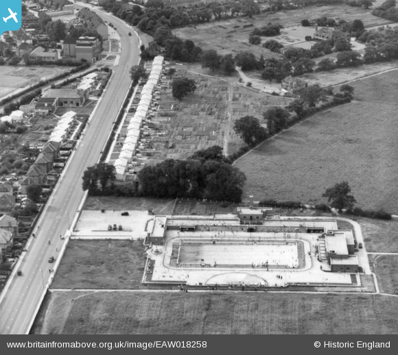
EAW018258 ENGLAND (1948). The Kingsbury Lido, Kingsbury, 1948. This image has been produced from a print.
© Copyright OpenStreetMap contributors and licensed by the OpenStreetMap Foundation. 2024. Cartography is licensed as CC BY-SA.
Nearby Images (3)
EAW018258

EPW061272

EAW018257

Details
| Title | [EAW018258] The Kingsbury Lido, Kingsbury, 1948. This image has been produced from a print. |
| Reference | EAW018258 |
| Date | 18-August-1948 |
| Link | |
| Place name | KINGSBURY |
| Parish | |
| District | |
| Country | ENGLAND |
| Easting / Northing | 519985, 188835 |
| Longitude / Latitude | -0.26797319675378, 51.58510736642 |
| National Grid Reference | TQ200888 |
Pins
 Janet |
Thursday 2nd of July 2015 01:23:10 PM | |
Janet |
Thursday 2nd of July 2015 01:21:52 PM | |
Harpie |
Tuesday 3rd of March 2015 03:38:47 PM | |
They're prefabs alright, but I doubt if those small structures were intended as air raid shelters. Prefabs were built after the war as a temporary measure to help deal with the housing shortage. The need for air raid shelters no longer existed. They have the outward appearance of Anderson shelters but they have not been sunk into the ground. Perhaps the government repurposed their stock of Anderson shelter materials in order to provide each prefab with a small garden shed. Quite a large area of vegetable allotments behind the prefabs in Roe Green Park. I imagine that the 'Dig For Victory' ethos continued along with rationing for some time after the war. |
The Laird |
Sunday 18th of November 2018 06:30:16 PM |


