
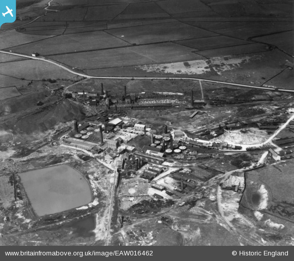
EAW016462 ENGLAND (1948). The Hepworth Iron Works (manufacturer of clay products) and environs, Crow Edge, 1948. This image has been produced from a print.
© Copyright OpenStreetMap contributors and licensed by the OpenStreetMap Foundation. 2024. Cartography is licensed as CC BY-SA.
Nearby Images (35)
EAW016462
 and environs, Crow Edge, 1948. This image has been produced from a print.")
EPW057245

EPW057248

EPW057246

EAW016459
 and environs, Crow Edge, 1948")
EAW016460
 and environs, Crow Edge, 1948. This image has been produced from a print.")
EPW057249

EPW059554

EAW009167

EAW009162

EPW016224

EPW057247

EAW016466
 and environs, Crow Edge, 1948. This image has been produced from a print.")
EAW009160

EPW059553

EPW059555

EPW059557

EPW059558

EPW059552

EAW009169

EAW009163

EAW009159

EAW009170

EAW009166

EPW057244

EPW059556

EPW016226

EAW016464
 and environs, Crow Edge, 1948. This image has been produced from a print.")
EAW016465
 and environs, Crow Edge, 1948. This image has been produced from a print.")
EAW009164

EAW016463
 and environs, Crow Edge, 1948. This image has been produced from a print.")
EAW009168

EAW009165

EAW009171

EAW009161

Details
| Title | [EAW016462] The Hepworth Iron Works (manufacturer of clay products) and environs, Crow Edge, 1948. This image has been produced from a print. |
| Reference | EAW016462 |
| Date | 9-June-1948 |
| Link | |
| Place name | CROW EDGE |
| Parish | DUNFORD |
| District | |
| Country | ENGLAND |
| Easting / Northing | 418084, 404798 |
| Longitude / Latitude | -1.7270946594404, 53.539271904329 |
| National Grid Reference | SE181048 |
Pins
Be the first to add a comment to this image!


