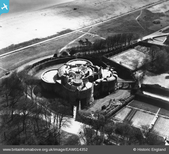
EAW014352 ENGLAND (1948). Walmer Castle, Walmer, 1948. This image has been produced from a print.
© Copyright OpenStreetMap contributors and licensed by the OpenStreetMap Foundation. 2024. Cartography is licensed as CC BY-SA.
Nearby Images (10)
Details
| Title | [EAW014352] Walmer Castle, Walmer, 1948. This image has been produced from a print. |
| Reference | EAW014352 |
| Date | 13-April-1948 |
| Link | |
| Place name | WALMER |
| Parish | WALMER |
| District | |
| Country | ENGLAND |
| Easting / Northing | 637750, 150091 |
| Longitude / Latitude | 1.4036220661113, 51.19995854223 |
| National Grid Reference | TR378501 |
Pins
Be the first to add a comment to this image!


![[EAW014352] Walmer Castle, Walmer, 1948. This image has been produced from a print.](http://britainfromabove.org.uk/sites/all/libraries/aerofilms-images/public/100x100/EAW/014/EAW014352.jpg)
![[EAW014351] Walmer Castle, Walmer, 1948. This image has been produced from a print.](http://britainfromabove.org.uk/sites/all/libraries/aerofilms-images/public/100x100/EAW/014/EAW014351.jpg)
![[EPW009207] Walmer Castle, Walmer, 1923](http://britainfromabove.org.uk/sites/all/libraries/aerofilms-images/public/100x100/EPW/009/EPW009207.jpg)
![[EAW014347] Walmer Castle, Walmer, 1948. This image has been produced from a print.](http://britainfromabove.org.uk/sites/all/libraries/aerofilms-images/public/100x100/EAW/014/EAW014347.jpg)
![[EAW014350] Walmer Castle, Walmer, 1948. This image has been produced from a print.](http://britainfromabove.org.uk/sites/all/libraries/aerofilms-images/public/100x100/EAW/014/EAW014350.jpg)
![[EAW014349] Walmer Castle, Walmer, 1948. This image has been produced from a print.](http://britainfromabove.org.uk/sites/all/libraries/aerofilms-images/public/100x100/EAW/014/EAW014349.jpg)
![[EAW014348] Walmer Castle, Walmer, 1948. This image has been produced from a print.](http://britainfromabove.org.uk/sites/all/libraries/aerofilms-images/public/100x100/EAW/014/EAW014348.jpg)
![[EPW035525] Walmer Castle, Walmer, 1931. This image has been produced from a copy-negative.](http://britainfromabove.org.uk/sites/all/libraries/aerofilms-images/public/100x100/EPW/035/EPW035525.jpg)
![[EPW035431] Walmer Artillery Castle and Gardens, Walmer, 1931](http://britainfromabove.org.uk/sites/all/libraries/aerofilms-images/public/100x100/EPW/035/EPW035431.jpg)
![[EAW020485] Walmer Castle and environs, Walmer, 1948. This image was marked by Aerofilms Ltd for photo editing.](http://britainfromabove.org.uk/sites/all/libraries/aerofilms-images/public/100x100/EAW/020/EAW020485.jpg)


