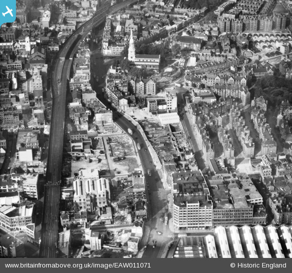
EAW011071 ENGLAND (1947). Shoreditch High Street, the Broad Street Extension Railway and St Leonard's Church, Shoreditch, 1947
© Copyright OpenStreetMap contributors and licensed by the OpenStreetMap Foundation. 2024. Cartography is licensed as CC BY-SA.
Nearby Images (2)
EAW011071

EAW011139

Details
| Title | [EAW011071] Shoreditch High Street, the Broad Street Extension Railway and St Leonard's Church, Shoreditch, 1947 |
| Reference | EAW011071 |
| Date | 30-September-1947 |
| Link | |
| Place name | SHOREDITCH |
| Parish | |
| District | |
| Country | ENGLAND |
| Easting / Northing | 533481, 182470 |
| Longitude / Latitude | -0.075682291113795, 51.524867396155 |
| National Grid Reference | TQ335825 |
Pins
 John Wass |
Wednesday 24th of June 2015 03:14:00 PM | |
John Wass |
Wednesday 24th of June 2015 03:13:30 PM | |
 Class31 |
Saturday 24th of January 2015 07:25:03 AM | |
Class31 |
Monday 12th of May 2014 10:37:15 AM | |
LondonerN1 |
Tuesday 10th of December 2013 06:57:22 PM | |
S00Z |
Tuesday 5th of November 2013 12:48:55 PM | |
S00Z |
Tuesday 5th of November 2013 12:48:26 PM | |
S00Z |
Tuesday 5th of November 2013 12:47:45 PM | |
S00Z |
Tuesday 5th of November 2013 12:47:05 PM |