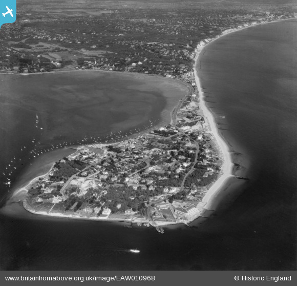
EAW010968 ENGLAND (1947). Sandbanks and Poole Head, Sandbanks, from the south-west, 1947
© Copyright OpenStreetMap contributors and licensed by the OpenStreetMap Foundation. 2024. Cartography is licensed as CC BY-SA.
Nearby Images (9)
EAW010968

EPW041055

EPW041060

EPW041056

EPW032301

EPW037413

EAW010969

EPW032298

EAW010961

Details
| Title | [EAW010968] Sandbanks and Poole Head, Sandbanks, from the south-west, 1947 |
| Reference | EAW010968 |
| Date | 24-September-1947 |
| Link | |
| Place name | SANDBANKS |
| Parish | |
| District | |
| Country | ENGLAND |
| Easting / Northing | 403824, 87228 |
| Longitude / Latitude | -1.9458649913761, 50.684116604934 |
| National Grid Reference | SZ038872 |
Pins
 redmist |
Monday 25th of March 2024 08:27:52 PM | |
redmist |
Monday 25th of March 2024 07:52:08 PM | |
redmist |
Sunday 9th of August 2020 11:47:04 AM | |
MikeMist |
Friday 20th of September 2019 07:20:59 PM | |
 Class31 |
Monday 10th of March 2014 11:31:16 AM | |
Class31 |
Monday 10th of March 2014 11:31:01 AM | |
Class31 |
Monday 10th of March 2014 11:30:16 AM | |
Class31 |
Monday 10th of March 2014 11:26:18 AM | |
Class31 |
Monday 10th of March 2014 11:24:02 AM |