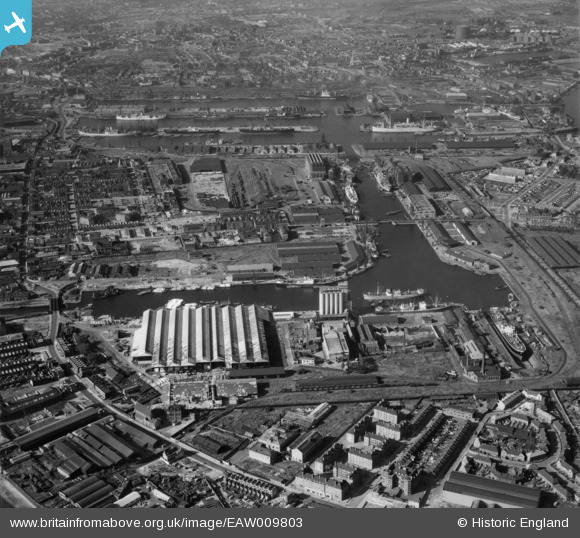
EAW009803 ENGLAND (1947). The West India Docks and Millwall Dock, Isle of Dogs, 1947

© Copyright OpenStreetMap contributors and licensed by the OpenStreetMap Foundation. 2024. Cartography is licensed as CC BY-SA.

Nearby Images (14)

EAW009803
  0° 0m
EPW044132
  333° 24m
EAW112904
  355° 85m
EPW044131
  189° 100m
EAW021721
  1° 119m
EPW046145
  194° 170m
EAW011757
  170° 208m
EPW046146
  181° 220m
EPW046147
  180° 233m
EAW011759
  193° 234m
EPW060548
  168° 246m
EPW044130
  209° 249m
EPW044128
  330° 279m
EPW044133
  43° 339m

Details

Title [EAW009803] The West India Docks and Millwall Dock, Isle of Dogs, 1947
Reference EAW009803
Date 1-September-1947
Link
Place name ISLE OF DOGS
Parish
District
Country ENGLAND
Easting / Northing 537550, 179220
Longitude / Latitude -0.018327178765288, 51.494682753974
National Grid Reference TQ376792

Pins

Approx position of a 2ndWW barrage balloon operating site.

redmist
Wednesday 3rd of November 2021 10:30:19 PM
Approx position of a 2ndWW barrage balloon operating site.

redmist
Wednesday 3rd of November 2021 10:10:40 PM
Harbinger School. First school I attended, Was allowed to get the bus (either 56 or 277) on the way to school as there was no major roads to cross. Cost was 2d as I recall. Had to walk home to Dunbar House at the end of the day. No school run. The only time I recall getting a lift home was when the Thames overflowed, probably at a spring tide, and an uncle piggy backed me home through the flooded streets.

Grollo
Friday 7th of March 2014 07:22:21 AM
The Mudchute. The name derived from the area where the spoil from the construction of the docks was deposited.

Grollo
Friday 7th of March 2014 07:13:24 AM
Glengall Bridge. The following has been copied from the web. I remember using this bridge as it was the shortest route from Dunbar House to the Recreation Ground at East Ferry Road. When the original rolling drawbridge broke down again in 1945, it was replaced with a concrete-filled barge, moored between the knuckles as a pontoon for pedestrians.
This picture of the second bridge was taken in the early 1960's by George Charnley, a PLA lock foreman and keen amateur photographer, who lived in nearby Mellish Street.  This flimsy and slightly wobbly little bridge was in place around 1945 and lasted until 1965, when it was replaced the Glass Bridge. This is the only known picture of the bridge and only recently came to light.

The barge-bridge and the knuckles in the dock had impeded the PLA's post-war modernization plans. Their replacement with an elevated walkway came under consideration from 1950, but before accepting this as necessary, the Port of London Authority (PLA) sought Poplar Borough Council's agreement to the displacement of the right of way. There was strong local opposition and in 1958 the PLA asked Parliament for power to close the route. The Council, the LCC and Charles Key, the local MP, forced the PLA to reconsider and prepare schemes for adapting the pedestrian crossing. 


Grollo
Friday 7th of March 2014 07:08:36 AM
The George Public House

Grollo
Friday 7th of March 2014 06:54:35 AM
Dunbar House built 1939

Grollo
Thursday 6th of March 2014 11:41:41 PM

Scrape
Saturday 22nd of February 2014 11:38:46 PM