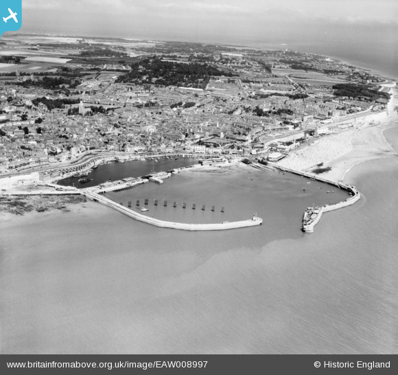
EAW008997 ENGLAND (1947). Royal Harbour and the town, Ramsgate, from the south, 1947
© Copyright OpenStreetMap contributors and licensed by the OpenStreetMap Foundation. 2024. Cartography is licensed as CC BY-SA.
Nearby Images (11)
EAW008997

EPW000595

EPW042862

EPW000375

EPW000380

EAW008998

EAW006626

EAW020488

EAW020487

EAW696658

EAW008999

Details
| Title | [EAW008997] Royal Harbour and the town, Ramsgate, from the south, 1947 |
| Reference | EAW008997 |
| Date | 12-August-1947 |
| Link | |
| Place name | RAMSGATE |
| Parish | RAMSGATE |
| District | |
| Country | ENGLAND |
| Easting / Northing | 638365, 164196 |
| Longitude / Latitude | 1.4218095407493, 51.326321015735 |
| National Grid Reference | TR384642 |
Pins
 Sparky |
Saturday 22nd of December 2018 06:56:42 PM | |
 |
John W |
Friday 7th of October 2016 09:26:08 PM |
 Alan McFaden |
Friday 11th of July 2014 06:06:48 PM | |
Alan McFaden |
Friday 11th of July 2014 05:50:43 PM | |
Alan McFaden |
Friday 11th of July 2014 05:49:57 PM | |
Alan McFaden |
Friday 11th of July 2014 05:49:12 PM | |
Alan McFaden |
Friday 11th of July 2014 05:48:49 PM | |
Alan McFaden |
Friday 11th of July 2014 05:48:11 PM |