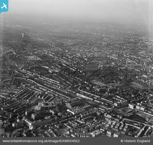
EAW004912 ENGLAND (1947). Holland Park and environs, Kensington, from the south-west, 1947
© Copyright OpenStreetMap contributors and licensed by the OpenStreetMap Foundation. 2024. Cartography is licensed as CC BY-SA.
Nearby Images (24)
Details
| Title | [EAW004912] Holland Park and environs, Kensington, from the south-west, 1947 |
| Reference | EAW004912 |
| Date | April-1947 |
| Link | |
| Place name | KENSINGTON |
| Parish | |
| District | |
| Country | ENGLAND |
| Easting / Northing | 524393, 179203 |
| Longitude / Latitude | -0.20778010249215, 51.497578687988 |
| National Grid Reference | TQ244792 |
Pins
 Karhedron |
Tuesday 5th of April 2022 06:49:32 AM | |
 brianbeckett |
Tuesday 14th of October 2014 11:27:46 PM | |
 Alan McFaden |
Monday 19th of May 2014 10:16:46 AM |


![[EAW004912] Holland Park and environs, Kensington, from the south-west, 1947](http://britainfromabove.org.uk/sites/all/libraries/aerofilms-images/public/100x100/EAW/004/EAW004912.jpg)
![[EAW022040] Charles House under construction, Warwick Road and environs, Kensington, from the north-west, 1949](http://britainfromabove.org.uk/sites/all/libraries/aerofilms-images/public/100x100/EAW/022/EAW022040.jpg)
![[EPW006523] The Exhibition Centre, Olympia, 1921](http://britainfromabove.org.uk/sites/all/libraries/aerofilms-images/public/100x100/EPW/006/EPW006523.jpg)
![[EAW022042] The Exhibition Centre and Kensington (Olympia) Station, Olympia, 1949](http://britainfromabove.org.uk/sites/all/libraries/aerofilms-images/public/100x100/EAW/022/EAW022042.jpg)
![[EAW009112] The Olympia Exhibition Centre and environs, West Kensington, 1947](http://britainfromabove.org.uk/sites/all/libraries/aerofilms-images/public/100x100/EAW/009/EAW009112.jpg)
![[EAW022039] The Exhibition Centre and Kensington (Olympia) Station, Olympia, 1949](http://britainfromabove.org.uk/sites/all/libraries/aerofilms-images/public/100x100/EAW/022/EAW022039.jpg)
![[EPW010196] The Olympia Exhibition Hall, Olympia, 1924. This image has been produced from a print.](http://britainfromabove.org.uk/sites/all/libraries/aerofilms-images/public/100x100/EPW/010/EPW010196.jpg)
![[EPW045413] The Exhibition Centre and environs, Olympia, 1934. This image has been produced from a damaged negative.](http://britainfromabove.org.uk/sites/all/libraries/aerofilms-images/public/100x100/EPW/045/EPW045413.jpg)
![[EAW022041] The Exhibition Centre and Kensington (Olympia) Station, Olympia, 1949](http://britainfromabove.org.uk/sites/all/libraries/aerofilms-images/public/100x100/EAW/022/EAW022041.jpg)
![[EPW025092] The Olympia Exhibition Centre, New Hall, Kensington (Addison Road) station and environs, West Kensington, 1928](http://britainfromabove.org.uk/sites/all/libraries/aerofilms-images/public/100x100/EPW/025/EPW025092.jpg)
![[EPW006522] The Exhibition Centre, Olympia, 1921](http://britainfromabove.org.uk/sites/all/libraries/aerofilms-images/public/100x100/EPW/006/EPW006522.jpg)
![[EAW022038] The Exhibition Centre and Kensington (Olympia) Station, Olympia, 1949](http://britainfromabove.org.uk/sites/all/libraries/aerofilms-images/public/100x100/EAW/022/EAW022038.jpg)
![[EPW010194] The Olympia Exhibition Hall, Olympia, 1924. This image has been produced from a copy-negative marked by Aerofilms Ltd for photo editing.](http://britainfromabove.org.uk/sites/all/libraries/aerofilms-images/public/100x100/EPW/010/EPW010194.jpg)
![[EPW010195] The Olympia Exhibition Hall, Olympia, 1924. This image has been produced from a print.](http://britainfromabove.org.uk/sites/all/libraries/aerofilms-images/public/100x100/EPW/010/EPW010195.jpg)
![[EPW025093] The Olympia Exhibition Centre, New Hall, Kensington (Addison Road) station and environs, West Kensington, 1928](http://britainfromabove.org.uk/sites/all/libraries/aerofilms-images/public/100x100/EPW/025/EPW025093.jpg)
![[EPW025090] The Olympia Exhibition Centre, New Hall, Kensington (Addison Road) station and environs, West Kensington, 1928](http://britainfromabove.org.uk/sites/all/libraries/aerofilms-images/public/100x100/EPW/025/EPW025090.jpg)
![[EPR000403] The Olympia Exhibition Centre, West Kensington, 1934](http://britainfromabove.org.uk/sites/all/libraries/aerofilms-images/public/100x100/EPR/000/EPR000403.jpg)
![[EPW025089] The Olympia Exhibition Centre, New Hall, Post Office Savings Bank and environs, West Kensington, 1928](http://britainfromabove.org.uk/sites/all/libraries/aerofilms-images/public/100x100/EPW/025/EPW025089.jpg)
![[EPW024267] The Olympia Exhibition Centre and Post Office Savings Bank, Hammersmith, 1928](http://britainfromabove.org.uk/sites/all/libraries/aerofilms-images/public/100x100/EPW/024/EPW024267.jpg)
![[EPW059340] Hammersmith Road and environs including Olympia and the Post Office Savings Bank, Hammersmith, 1938](http://britainfromabove.org.uk/sites/all/libraries/aerofilms-images/public/100x100/EPW/059/EPW059340.jpg)
![[EPW025091] The Olympia Exhibition Centre and environs, West Kensington, 1928](http://britainfromabove.org.uk/sites/all/libraries/aerofilms-images/public/100x100/EPW/025/EPW025091.jpg)
![[EAW022043] The Exhibition Centre and Kensington (Olympia) Station, Olympia, 1949](http://britainfromabove.org.uk/sites/all/libraries/aerofilms-images/public/100x100/EAW/022/EAW022043.jpg)
![[EAW018714] The Exhibition Centre, Olympia, 1948. This image has been produced from a print.](http://britainfromabove.org.uk/sites/all/libraries/aerofilms-images/public/100x100/EAW/018/EAW018714.jpg)
![[EPW010179] Olympia and surrounding area, West Kensington, 1924. This image has been produced from a print.](http://britainfromabove.org.uk/sites/all/libraries/aerofilms-images/public/100x100/EPW/010/EPW010179.jpg)


