
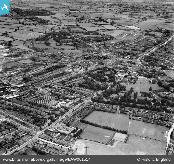
EAW001514 ENGLAND (1946). The town, Braintree, from the north-east, 1946
© Copyright OpenStreetMap contributors and licensed by the OpenStreetMap Foundation. 2024. Cartography is licensed as CC BY-SA.
Nearby Images (2)
EAW001514

EPW039749

Details
| Title | [EAW001514] The town, Braintree, from the north-east, 1946 |
| Reference | EAW001514 |
| Date | 5-July-1946 |
| Link | |
| Place name | BRAINTREE |
| Parish | |
| District | |
| Country | ENGLAND |
| Easting / Northing | 576263, 223367 |
| Longitude / Latitude | 0.56117662078895, 51.880525545499 |
| National Grid Reference | TL763234 |
Pins
 Paul S |
Thursday 23rd of July 2020 07:35:05 PM | |
Paul S |
Monday 14th of May 2018 06:43:43 PM | |
Paul S |
Monday 14th of May 2018 06:39:36 PM | |
Paul S |
Monday 14th of May 2018 06:36:09 PM | |
Paul S |
Monday 14th of May 2018 06:33:58 PM | |
Sparky |
Saturday 23rd of September 2017 11:07:05 AM | |
Sparky |
Saturday 23rd of September 2017 11:05:53 AM | |
Paul S |
Thursday 3rd of October 2013 05:19:56 PM | |
Paul S |
Thursday 3rd of October 2013 05:17:51 PM | |
Paul S |
Thursday 3rd of October 2013 05:14:37 PM | |
Paul S |
Thursday 3rd of October 2013 05:14:07 PM | |
Paul S |
Thursday 3rd of October 2013 05:12:36 PM | |
Paul S |
Thursday 3rd of October 2013 05:11:52 PM | |
Paul S |
Thursday 3rd of October 2013 05:09:27 PM | |
Paul S |
Thursday 3rd of October 2013 05:08:16 PM | |
Paul S |
Thursday 3rd of October 2013 05:07:40 PM | |
Paul S |
Thursday 3rd of October 2013 05:06:43 PM | |
Paul S |
Thursday 3rd of October 2013 05:03:50 PM | |
Paul S |
Thursday 3rd of October 2013 05:02:13 PM | |
Paul S |
Thursday 3rd of October 2013 05:01:34 PM | |
Paul S |
Thursday 3rd of October 2013 05:00:20 PM | |
Paul S |
Thursday 3rd of October 2013 04:58:54 PM | |
Paul S |
Thursday 3rd of October 2013 04:57:54 PM |
User Comment Contributions
This photograph includes very much all that comprised my life until I left home for University in the early 70s. I can recognise all that I see but much has now gone and exists in fewer memories as time passes. Shame really. |
Paul S |
Thursday 3rd of October 2013 05:16:51 PM |


