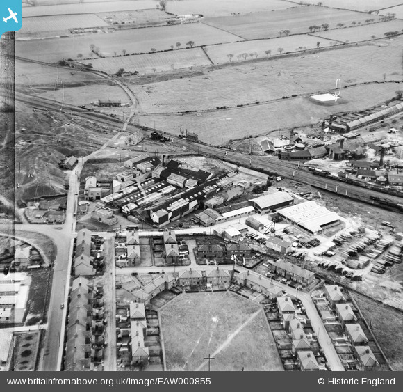
EAW000855 ENGLAND (1946). Durham Timber Co Timber Yard and South End Villas, Crook, 1946
© Copyright OpenStreetMap contributors and licensed by the OpenStreetMap Foundation. 2024. Cartography is licensed as CC BY-SA.
Nearby Images (29)
Details
| Title | [EAW000855] Durham Timber Co Timber Yard and South End Villas, Crook, 1946 |
| Reference | EAW000855 |
| Date | 15-May-1946 |
| Link | |
| Place name | CROOK |
| Parish | |
| District | |
| Country | ENGLAND |
| Easting / Northing | 416161, 534936 |
| Longitude / Latitude | -1.7491472580429, 54.709072318547 |
| National Grid Reference | NZ162349 |


![[EAW000855] Durham Timber Co Timber Yard and South End Villas, Crook, 1946](http://britainfromabove.org.uk/sites/all/libraries/aerofilms-images/public/100x100/EAW/000/EAW000855.jpg)
![[EPW060894] The Durham Timber Co Sawmill and Castle Close, Crook, 1939](http://britainfromabove.org.uk/sites/all/libraries/aerofilms-images/public/100x100/EPW/060/EPW060894.jpg)
![[EAW016873] Marshall Richards Machine Company Works and South End Villas, Crook, 1948](http://britainfromabove.org.uk/sites/all/libraries/aerofilms-images/public/100x100/EAW/016/EAW016873.jpg)
![[EAW016875] Marshall Richards Machine Company Works, Crook, 1948. This image was marked by Aerofilms Ltd for photo editing.](http://britainfromabove.org.uk/sites/all/libraries/aerofilms-images/public/100x100/EAW/016/EAW016875.jpg)
![[EPW060893] The Durham Timber Co Sawmill and the Eclipse Silica Brickworks, Crook, 1939](http://britainfromabove.org.uk/sites/all/libraries/aerofilms-images/public/100x100/EPW/060/EPW060893.jpg)
![[EPW060897] The Durham Timber Co Sawmill, Crook, 1939](http://britainfromabove.org.uk/sites/all/libraries/aerofilms-images/public/100x100/EPW/060/EPW060897.jpg)
![[EAW016865] Marshall Richards Machine Company Works, Crook, from the north-west, 1948](http://britainfromabove.org.uk/sites/all/libraries/aerofilms-images/public/100x100/EAW/016/EAW016865.jpg)
![[EAW000856] Durham Timber Co Timber Yard and South End Villas, Crook, 1946](http://britainfromabove.org.uk/sites/all/libraries/aerofilms-images/public/100x100/EAW/000/EAW000856.jpg)
![[EPW060890] The Durham Timber Co Sawmill and the South End Villas, Crook, 1939](http://britainfromabove.org.uk/sites/all/libraries/aerofilms-images/public/100x100/EPW/060/EPW060890.jpg)
![[EPW060892] The Durham Timber Co Sawmill and housing off New Road, Crook, 1939](http://britainfromabove.org.uk/sites/all/libraries/aerofilms-images/public/100x100/EPW/060/EPW060892.jpg)
![[EPW060896] The Durham Timber Co Sawmill, Crook, 1939](http://britainfromabove.org.uk/sites/all/libraries/aerofilms-images/public/100x100/EPW/060/EPW060896.jpg)
![[EPW060891] The Durham Timber Co Sawmill and housing off New Road, Crook, 1939](http://britainfromabove.org.uk/sites/all/libraries/aerofilms-images/public/100x100/EPW/060/EPW060891.jpg)
![[EPW060887] The Durham Timber Co Sawmill and housing off New Road, Crook, 1939](http://britainfromabove.org.uk/sites/all/libraries/aerofilms-images/public/100x100/EPW/060/EPW060887.jpg)
![[EAW000857] Durham Timber Co Timber Yard and South End Villas, Crook, 1946](http://britainfromabove.org.uk/sites/all/libraries/aerofilms-images/public/100x100/EAW/000/EAW000857.jpg)
![[EAW016867] Marshall Richards Machine Company Works, Crook, 1948](http://britainfromabove.org.uk/sites/all/libraries/aerofilms-images/public/100x100/EAW/016/EAW016867.jpg)
![[EAW016869] Marshall Richards Machine Company Works and environs, Crook, 1948. This image was marked by Aerofilms Ltd for photo editing.](http://britainfromabove.org.uk/sites/all/libraries/aerofilms-images/public/100x100/EAW/016/EAW016869.jpg)
![[EAW016870] Marshall Richards Machine Company Works and environs, Crook, 1948. This image was marked by Aerofilms Ltd for photo editing.](http://britainfromabove.org.uk/sites/all/libraries/aerofilms-images/public/100x100/EAW/016/EAW016870.jpg)
![[EPW060888] The Durham Timber Co Sawmill, housing off New Road and the surrounding countryside, Crook, 1939](http://britainfromabove.org.uk/sites/all/libraries/aerofilms-images/public/100x100/EPW/060/EPW060888.jpg)
![[EAW000858A] Durham Timber Co Timber Yard and the Eclipse Silica Brickworks, Crook, 1946](http://britainfromabove.org.uk/sites/all/libraries/aerofilms-images/public/100x100/EAW/000/EAW000858A.jpg)
![[EAW016866] Marshall Richards Machine Company Works, Crook, from the north-east, 1948. This image was marked by Aerofilms Ltd for photo editing.](http://britainfromabove.org.uk/sites/all/libraries/aerofilms-images/public/100x100/EAW/016/EAW016866.jpg)
![[EPW060895] The Durham Timber Co Sawmill, the South End Villas and the town, Crook, 1939](http://britainfromabove.org.uk/sites/all/libraries/aerofilms-images/public/100x100/EPW/060/EPW060895.jpg)
![[EAW016871] Marshall Richards Machine Company Works and environs, Crook, from the south-east, 1948](http://britainfromabove.org.uk/sites/all/libraries/aerofilms-images/public/100x100/EAW/016/EAW016871.jpg)
![[EAW016876] Marshall Richards Machine Company Works, Crook, from the north-east, 1948](http://britainfromabove.org.uk/sites/all/libraries/aerofilms-images/public/100x100/EAW/016/EAW016876.jpg)
![[EAW000858] Durham Timber Co Timber Yard, South End Villas and environs, Crook, from the north-east, 1946](http://britainfromabove.org.uk/sites/all/libraries/aerofilms-images/public/100x100/EAW/000/EAW000858.jpg)
![[EAW016864] Marshall Richards Machine Company Works and environs, Crook, from the south-east, 1948](http://britainfromabove.org.uk/sites/all/libraries/aerofilms-images/public/100x100/EAW/016/EAW016864.jpg)
![[EAW016868] Marshall Richards Machine Company Works and environs, Crook, 1948. This image was marked by Aerofilms Ltd for photo editing.](http://britainfromabove.org.uk/sites/all/libraries/aerofilms-images/public/100x100/EAW/016/EAW016868.jpg)
![[EAW016874] Marshall Richards Machine Company Works, Crook, 1948. This image was marked by Aerofilms Ltd for photo editing.](http://britainfromabove.org.uk/sites/all/libraries/aerofilms-images/public/100x100/EAW/016/EAW016874.jpg)
![[EPW060889] The Durham Timber Co Sawmill, housing off New Road and the surrounding countryside, Crook, 1939](http://britainfromabove.org.uk/sites/all/libraries/aerofilms-images/public/100x100/EPW/060/EPW060889.jpg)
![[EAW016872] Marshall Richards Machine Company Works and South End Villas, Crook, from the north-east, 1948. This image was marked by Aerofilms Ltd for photo editing.](http://britainfromabove.org.uk/sites/all/libraries/aerofilms-images/public/100x100/EAW/016/EAW016872.jpg)


