
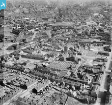
EAW000784 ENGLAND (1946). The area between Stafford Street, Whitehouse Street and Green Lane, Birchills, 1946

© Copyright OpenStreetMap contributors and licensed by the OpenStreetMap Foundation. 2024. Cartography is licensed as CC BY-SA.
Nearby Images (8)
EAW000784

EAW000783

EAW000785

EAW000781

EAW000780

EAW000786

EPW015055

EAW000782

Details
| Title | [EAW000784] The area between Stafford Street, Whitehouse Street and Green Lane, Birchills, 1946 |
| Reference | EAW000784 |
| Date | 11-May-1946 |
| Link | |
| Place name | BIRCHILLS |
| Parish | |
| District | |
| Country | ENGLAND |
| Easting / Northing | 401010, 299185 |
| Longitude / Latitude | -1.9850895398834, 52.590108818739 |
| National Grid Reference | SP010992 |
Pins
 Sparky |
Monday 25th of September 2017 06:09:11 PM | |
Sandwell Street Kid |
Tuesday 18th of March 2014 08:23:42 PM | |
Sandwell Street Kid |
Tuesday 18th of March 2014 08:22:20 PM | |
 |
Sandwell Street Kid |
Tuesday 18th of March 2014 08:20:43 PM |
Sandwell Street Kid |
Tuesday 18th of March 2014 08:02:43 PM | |
Sandwell Street Kid |
Tuesday 18th of March 2014 07:52:55 PM | |
Sandwell Street Kid |
Tuesday 18th of March 2014 07:51:33 PM | |
Sandwell Street Kid |
Tuesday 18th of March 2014 05:12:10 PM | |
Sandwell Street Kid |
Tuesday 18th of March 2014 05:10:32 PM | |
Sandwell Street Kid |
Tuesday 18th of March 2014 05:09:39 PM | |
Sandwell Street Kid |
Tuesday 18th of March 2014 05:09:01 PM | |
Sandwell Street Kid |
Tuesday 18th of March 2014 05:08:40 PM | |
Sandwell Street Kid |
Tuesday 18th of March 2014 04:53:22 PM | |
 |
Sandwell Street Kid |
Tuesday 18th of March 2014 04:52:24 PM |
Sandwell Street Kid |
Tuesday 18th of March 2014 04:35:36 PM | |
Sandwell Street Kid |
Tuesday 18th of March 2014 04:34:10 PM | |
Sandwell Street Kid |
Tuesday 18th of March 2014 04:33:34 PM | |
Sandwell Street Kid |
Tuesday 18th of March 2014 04:32:57 PM | |
Sandwell Street Kid |
Tuesday 18th of March 2014 04:32:06 PM | |
Sandwell Street Kid |
Tuesday 18th of March 2014 04:31:48 PM | |
Sandwell Street Kid |
Tuesday 18th of March 2014 04:31:02 PM | |
Sandwell Street Kid |
Tuesday 18th of March 2014 04:30:38 PM | |
Sandwell Street Kid |
Tuesday 18th of March 2014 04:30:18 PM | |
Sandwell Street Kid |
Tuesday 18th of March 2014 04:29:34 PM |


User Comment Contributions
 Another brilliant view of a Walsall long gone and so sharp too. |
Sandwell Street Kid |
Tuesday 18th of March 2014 04:27:53 PM |


