
Groups

Watford & District (S.W.Herts)
About the group A collection of images taken during the interwar period of Watford's growth and of some of the surrounding settlements such as Bushey, Oxhey and Rick
Created 3 August 2013

John Swain |
||
|
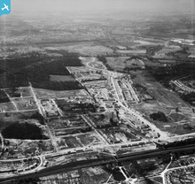
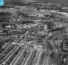
This view is looking in the opposite direction to EAW022130 and is thus a useful complement to the previous image depicting the emergence of the huge, sprawling London County Council estate at South Oxhey.
|
John Swain |
|
|
This estate became one of the most significant post-WWII developments in the London Region, with the majority of the 17,000 inhabitants moving out from the over-crowded, war-damaged Metropolis into this greenfield site.
|
John Swain |
|
|
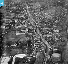
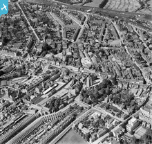
A classic shot of Watford taken looking north-west, along the axis of the famous old High Street, shortly after the conclusion of the second world war, when the population of the town was already over 70,000.
|
John Swain |
|
|
Oxhey Hall Estate is a notable example of Metroland 1930s housing, most of which has been designated a Conservation Area in more recent times.
|
John Swain |
|
|
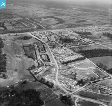
I wonder if Katy and her team are able to uncover some more recent shots from the Aerofilms archive of the area south of Oxhey Hall, which may show the early stages of the post-war London County Council's huge housing estate at South Oxhey, under construction between 1946 and 1950?
|
John Swain |
|
|
Hi John,
For England we are cataloguing in 1950 now. There'll be an upload of a further 6000 or so later-1940s English images in October. I fully expect more south-west Hertfordshire cover, because from 1946 Aerofilms Ltd were based in Elstree/Borehamwood. Just where in the area is another matter though! Depends on their job-lists and any speculative shots they took in transit, plus where they were flying Yours, Katy |
Katy Whitaker |
|
|
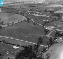
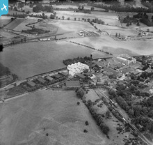
An attractive shot of part of Sandy Lodge Golf Course, looking north-west towards the newly-completed school, with the 1930-1985 Asbestos Works and the 1830-1980 Croxley Mills in the distance.
|
John Swain |
|
|
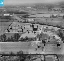
A rare picture of the newly-opened Merchant Taylors' School after its move from the City of London and which continues to thrive eight decades later. In the middle distance and background, in this view looking almost due north, are two of the more important factories in the area, the Asbestos Works and Croxley Mill, neither of which survived beyond the 1980s.
|
John Swain |
|
|
An interesting view, looking towards the north-west from the western edge of Oxhey Golf Course and Hampermill Spring, across an area that was to undergo development in the following decade, with factories set up on Tolpits Lane, between the LMS Railway Branch and the River Colne, in addition to Merchant Taylors' School.
|
John Swain |
|
|
A good, clear view of the 1923 Vicarage Road ground and home of Watford Football Club for almost a decade when this photo was taken, looking almost due east. In the foreground is the old 1838 Watford Union Workhouse, referred to on maps of the period as Shrodells Public Assistance Institution (PAI), which had been expanded in the late 19th century. In the 1940s, Shrodells PAI became part of the Wartime Emergency Medical Scheme, with 578 beds and a further 198 EMS beds. Under the National Health Service in 1948, Shrodells Hospital contained 464 general beds and was to undergo huge changes over the next half century, as it became part of Watford General.
Most of the streets labelled on the image were laid out by 1895. |
John Swain |
|
|
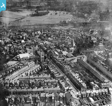
Watford is listed in 1936 as the sixth wealthiest town in the country, based on the purchasing power of the 65,000 inhabitants. This may not be one of the more salubrious neighbourhoods in the town, but it's worthy of study nevertheless.
|
John Swain |
|
|
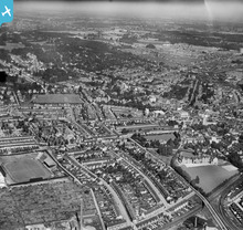
An interesting snapshot of Watford in the early Thirties, when the town continued to grow to around 56,000 inhabitants, from a figure of 45,000 in 1921. Looking north-west in this viewpoint, it's easy to appreciate how RAF pilots flying over Watford less than ten years hence would consider the urban area to be made up of parkland as much as industrial or commercial uses.
|
John Swain |
|
|
This famous old factory was a feature of the local landscape, in addition to being a major employer throughout 150 years, from 1830 until 1980.
|
John Swain |
|
|
A fine view looking north and west over the historic core of Watford, featuring many of the principal landmarks of the town, which appear to have survived six years of war. RAF pilots used to remark that Watford from the air in the 1940s contained plenty of open spaces and hardly resembled an important industrial centre. In fact, more bombs fell on the rural surroundings than on the town itself, perhaps reflecting upon the proximity to London.
|
John Swain |
|
|
A splendid image of Watford, looking north-east from West Watford just a year after the end of the Second World War, when the town's population had topped 65,000. Despite experiencing bomb damage, both from high explosives and incendiaries, throughout the hostilities, this part of the urban area appears to be relatively intact.
|
John Swain |
|
|
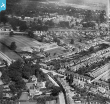
A varied and interesting scene at the southern extremity of Watford and the adjoining areas of Bushey and Oxhey.
|
John Swain |
|
|
[EPW059401] The Harts Spring Gravel Pits and the village, Patchetts Green, from the south-west, 1938
The site of these gravel pits is bounded by Hartspring Lane on the left and what is now the A41 (running left to right in the bottom third of the picture. The site now houses COSTCO, Hilton Hotel, a Traveler site and Winfield Garden & Building Supplies.Patchetts Green is to the right of centre in the photo. |

Brian H |
|
|
All past and present inhabitants of SW Herts should be able to identify with this image of Watford in its prewar heyday.
|
John Swain |
|
|
A rare image of the fine 1912 clubhouse on this once-famous Oxhey Golf Course (1912-1952), less than three miles to the south of Watford Town.
|
John Swain |
|
|
An interesting comparison with the earlier 1926 shot of a similar area and the obvious use of the new A41 route on the eastern side of Watford.
|
John Swain |
|
|
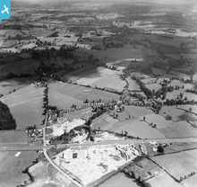
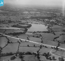
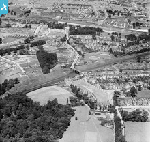
A rural scene less than three miles from the centre of Watford, with major changes taking place in the road network in the form of the Watford By-Pass/North Western Avenue, completed in 1926. Further changes were due to take place in the 1960s, notably the construction of the M1 Motorway.
|
John Swain |
|
|
A popular image for inclusion in this group which has attracted plenty of comments in the last while.
|
John Swain |
|
|
This is an attractive picture of the old town of Ricky seen from the south and with the former LMS station on Church Street, at the terminus of the 1862 LMS branch from Watford. Despite living within one mile of this short branch line, on the postwar housing estate at South Oxhey, I never witnessed a single train on this track between 1953 and 1962! However, I've walked the popular Ebury Way on several occasions once the tracks were eventually removed in the 1980s.
|
John Swain |
|
|
At the time (1932), this was the main cricket ground in Hertfordshire, hosting the Minor County match with Norfolk on July 13 and 14, in addition to West Herts being one of the strongest club sides in the district. Altogether, this is a fine, clear image of a well-known location in central Watford, which has remained intact to the present day despite the huge postwar changes in transport links and urban landscape in the vicinity.
|
John Swain |
|
|
Another exceptional image of the urban core of Watford during the early 1930s, when the total population topped 56,000, and would continue to grow throughout the decade to reach 65,000 by the outbreak of hostilities in September 1939, an overall increase of almost 50% since 1919.
|
John Swain |
|
 |
John Swain |
|
|
An excellent view of the area between Oxhey, Bushey and south Watford, with an interesting mix of land uses in the period immediately prior to World war II.
|
John Swain |
|
|
An attractive shot of Bushey High Street looking north-west towards Watford.
|
John Swain |
|
|
This fine image of the 1922 works at Scammell Lorries, West Watford, is worth including because of the importance of the factory as a major source of employment from 1922 until 1987.
|
John Swain |
|
|
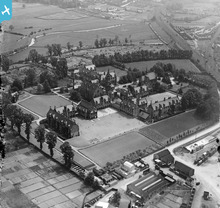
These buildings have been preserved into the present under Grade II Listed status and are thus deemed worthy of inclusion in the group featuring the growth and development of Watford.
|
John Swain |
|
|
It's also worth noting that the former Orphanage was featured on the popular postcards of the late Victorian and Edwardian periods.
|
John Swain |
|
|
Any group relating to the growth and importance of Watford must surely include a picture of the Main Line station at Watford Junction and this is probably the clearest image available on the website.
|
John Swain |
|
|
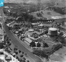
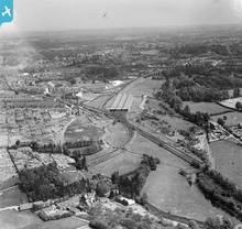
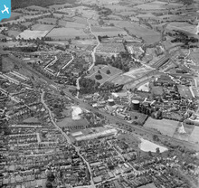
This image could justifiably gain inclusion in the "Railways" group selection, but suffice for the time being for it to be included in the "Watford & District" group, as it displays a pleasing mix of urban land uses at the south-east end of the town. I can still smell the distinctive aromas of this part of SW Herts in the 1950s: the sweet airs from Benskin's, mingling with the gasworks and the sulphur-laden pollution from the nearby railways.
|
John Swain |
|
|
I'm inclined to suggest this image for inclusion as it features a well-respected landmark in the central Watford community and shows the Town Hall area just prior to the construction of the new municipal offices which were opened four years later. The famous roundabout is already in place, a location well known to this correspondent in the 1950s.
|
John Swain |
|
|
This is a view looking in almost the opposite direction to a previous image featuring Vicarage Road and environs, and so is worth inclusion in this collection of photographs taken around the south side of the town over 80 years ago.
|
John Swain |
|
|
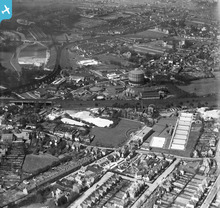
This is a rare view of the famous stadium at Vicarage Road and the home of Watford FC for about ten years when this picture was taken. It's also worthy of inclusion in other groups on this website, such as "Football Grounds". In the background is the 1897 electricity generating station, with coal brought in from the north Midlands, via a railway siding, which served the town until the late 1960s, when it was demolished in favour of a new gas/oil power station.
|
John Swain |
|
|
It is gratifying to know to older Watfordians that two of Watford's Grade I Listed buildings, St.Mary's Parish Church and Holy Rood RC Church remain extant despite all the post-1960 changes that have been inflicted on the town. A fine image of Watford from its prewar heyday.
|
John Swain |
|
|
As a major employer in Watford until the 1960s, Benskin's Brewery is worth inclusion in a group featuring Watford during the interwar years, 1919-1939.
|
John Swain |
|
|
A pic as fine as this one could gain inclusion in several groups which have already been formed, but it well worth adding this image to the growing collection on the Watford and SW Herts site.
|
John Swain |
|
|
Another sharp and detailed image which, again, has attracted plenty of comment from viewers, including the not-so-ordinary bloke from Bushey Meads! I hope he, among others, will consider joining this group in addition to those they are already members of. There seems to be a lot of interest shown in the photographs of the SW Herts area, which, in common with many parts of SE England, has undergone considerable change in my lifetime of almost 70 years!
|
John Swain |
|
|
An intriguing image which has attracted plenty of attention from individuals in the last while and is thus considered to be worthy of inclusion in this group.
|
John Swain |
|
|
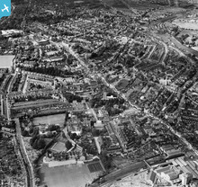
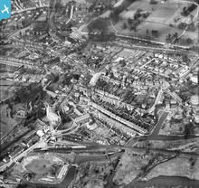
A fine view over the old town taken towards the end of the decade when the population of Watford had passed 50,000, but still most of the commercial activity was concentrated along the High Street or in adjoining properties.
|
John Swain |
|
 |
John Swain |
|
 |
John Swain |
|
|
During the 1920s and 1930s, Watford still had the appearance of an old-fashioned medieval market town and these times were captured for posterity by the long-running "Watford Observer" as well by the excellent images from the Aerofilms' collection.
|
John Swain |
|
|
An interesting photo of the southern margins of Watford and the varied land uses in the Colne valley near Oxhey.
|
John Swain |
|
|
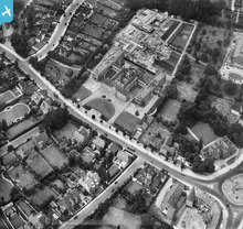
A view of the trimmed down Cassiobury Park taken during the same year when Cassiobury House was finally demolished and shortly after the November 1925 opening of the Watford Met Station, which itself is destined for closure in three years'time, when the new Croxley Link becomes operational.
|
John Swain |
|
|
I attended this famous old school from September 1954 until July 1961 and thus experienced some of the major changes which took place as the school continued to grow and develop. In the 1920s, only about 600 pupils were on roll, but this has more than doubled in the present century, to around 1,300 boys in 2013.
|
John Swain |
|
 |
John Swain |
|
|
Watford grew between 1920 and the outbreak of war in 1939 from a medium-sized market town of 45,000 to a thriving industrial and commercial centre approaching 65,000 in size. It was arguably one of the most prosperous towns in the south of England and colleagues are recommended to consult the numerous images on this website which depict the settlement in its heyday.
|
John Swain |


see image record